
How to checksum spatial datasets so you can prove they match
Problem statement
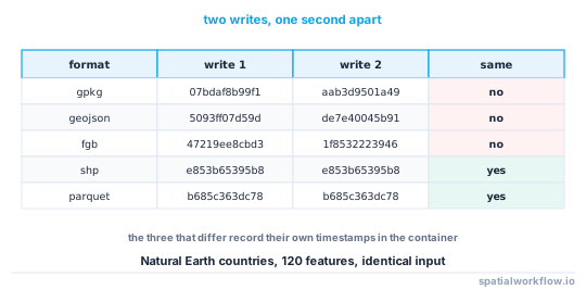
Two people want to be sure they have the same dataset. The obvious answer — hash the file — works for a download and fails for anything you produced yourself, because several spatial formats are not byte-reproducible. Writing the same 120-feature layer twice, one second apart, gave different SHA-256 digests:
| format | write 1 | write 2 | identical? |
|---|---|---|---|
| GeoPackage | 07bdaf8b99f16b91… |
aab3d9501a4994ba… |
no |
| GeoJSON | 5093ff07d59d9e5b… |
de7e40045b9125fa… |
no |
| FlatGeobuf | 47219ee8cbd3675b… |
1f85322239463732… |
no |
| Shapefile | e853b65395b8c83a… |
e853b65395b8c83a… |
yes |
| Parquet | b685c363dc78f752… |
b685c363dc78f752… |
yes |
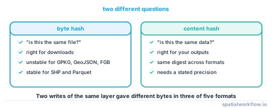
The three that differ embed timestamps or generator strings. So a byte hash answers "is this the same file?" and you usually want to ask "is this the same data?" — which needs a hash of the content, canonicalised so that the format's own choices do not change the answer.
Quick answer
Hash the data, not the container:
import hashlib, numpy as np, pandas as pd, shapely

def content_hash(gdf, decimals=9):
    """Stable across formats: geometry type, ring order, row order and column order."""
    geom = shapely.force_2d(gdf.geometry.values)
    geom = np.array([shapely.multipolygons([g]) if g.geom_type == "Polygon" else g
                     for g in geom])
    geom = shapely.normalize(geom)

    tab = pd.DataFrame(gdf.drop(columns=gdf.geometry.name)).astype(str)
    tab["_geometry"] = shapely.to_wkt(geom, rounding_precision=decimals)
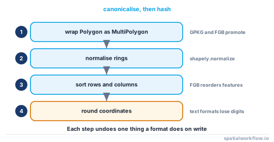
    tab = tab.reindex(sorted(tab.columns), axis=1)
    tab = tab.sort_values(list(tab.columns)).reset_index(drop=True)
    return hashlib.sha256(tab.to_csv(index=False).encode()).hexdigest()
Writing the same layer to GeoPackage, GeoJSON, FlatGeobuf, shapefile and Parquet and hashing each after reading it back gave one digest for all five at nine decimal places.
Step-by-step solution
1. Use a byte hash for files you received
For a download, the byte hash is exactly right: it proves you have the same bytes the publisher shipped, and any difference is corruption or tampering. Record it with the URL and the date.
2. Use a content hash for data you produced
For an output, the byte hash is unstable and therefore useless as a claim. Hash the canonicalised content instead, and record the canonicalisation parameters with the digest.
3. Normalise geometry type
GeoPackage and FlatGeobuf declare a single layer geometry type, so both promote every Polygon to MultiPolygon on write. In the test dataset — 64 MultiPolygons and 56 Polygons — both formats returned 120 MultiPolygons. Wrapping every Polygon in a MultiPolygon before hashing removes the difference.
4. Normalise ring order and orientation
shapely.normalize puts rings and coordinate sequences into a canonical order, so two topologically identical geometries stored with different winding hash the same.
5. Normalise row order
FlatGeobuf reorders features by a packed Hilbert R-tree, so the first feature in the file is not the first feature you wrote. Sorting the table before hashing makes the digest independent of storage order.
6. Choose a coordinate precision and state it
Text formats do not round-trip doubles exactly. A GeoJSON round trip left only 4 of 120 geometries bit-identical, with a maximum Hausdorff displacement of 9.8 × 10⁻¹⁴ degrees — about 0.01 micrometres, and enough to change a digest. Rounding to a stated precision when hashing absorbs it.
7. Or snap before writing, which is better
If you control the writer, snap coordinates to the precision the data deserves before you write. The same 120 features snapped to 10⁻⁶ degrees and round-tripped through GeoJSON came back with all 120 geometries bit-identical.
8. Record the digest with its recipe
A hash with no stated precision, normalisation and column handling cannot be reproduced by anyone else. Store the parameters next to the digest.
Code examples
Example 1 — the byte hash, done properly
import hashlib, pathlib

def file_hash(path, chunk=1 << 20):
    h = hashlib.sha256()
    with open(path, "rb") as fh:
        for block in iter(lambda: fh.read(chunk), b""):
            h.update(block)
    return h.hexdigest()

def dataset_hash(path):
    """Shapefiles are several files; hash them together, in a fixed order."""
    p = pathlib.Path(path)
    if p.suffix.lower() == ".shp":
        parts = sorted(p.parent.glob(p.stem + ".*"))
        h = hashlib.sha256()
        for part in parts:
            h.update(part.name.encode())
            h.update(file_hash(part).encode())
        return h.hexdigest()
    return file_hash(p)
Hashing the sidecar names as well as their contents is what stops a missing .prj from going unnoticed.
Example 2 — prove two files hold the same data
import geopandas as gpd

def same_data(a, b, decimals=9, rename_truncated=False):
    ga = gpd.read_parquet(a) if str(a).endswith(".parquet") else gpd.read_file(a)
    gb = gpd.read_parquet(b) if str(b).endswith(".parquet") else gpd.read_file(b)
    if rename_truncated and len(ga.columns) == len(gb.columns):
        gb.columns = list(ga.columns)          # shapefile truncates to 10 characters
    return content_hash(ga, decimals) == content_hash(gb, decimals)
The rename_truncated flag is not a hack to hide a difference — it is the explicit acknowledgement that a shapefile cannot carry a column called population_estimate_2019, which it stores as population.
Example 3 — a raster content hash
import rasterio, hashlib, numpy as np

def raster_content_hash(path, round_to=None):
    with rasterio.open(path) as src:
        h = hashlib.sha256()
        h.update(str(src.crs).encode())
        h.update(np.array(src.transform[:6], dtype="float64").round(9).tobytes())
        h.update(f"{src.width}x{src.height}x{src.count}".encode())
        for i in range(1, src.count + 1):
            band = src.read(i)
            if round_to is not None and np.issubdtype(band.dtype, np.floating):
                band = np.round(band, round_to)
            nodata = src.nodatavals[i - 1]
            if nodata is not None and np.isnan(nodata):
                band = np.where(np.isnan(band), np.float64(-1e308), band)
            h.update(np.ascontiguousarray(band).tobytes())
        return h.hexdigest()
The NaN substitution matters: nan != nan, so two byte-identical arrays of NaN hash the same but two arrays that should be equal after a float operation may not. Replacing NaN with a sentinel before hashing makes the comparison say what you mean.
Explanation
Why GeoPackage and GeoJSON are not byte-reproducible
A GeoPackage records its own creation and last-change timestamps in gpkg_contents, so two writes a second apart differ. GeoJSON and FlatGeobuf as written by GDAL carry generator or timestamp information of their own. Shapefile and Parquet, in this test, produced identical bytes for identical input — which makes them the two formats where a byte hash is a usable output check.
Why the format's normalisation is the interesting part
Every difference in the table above is a format doing something reasonable: declaring one geometry type per layer, ordering features spatially for fast reads, writing coordinates as decimal text. None is a bug, and all of them change the bytes. Canonicalising before hashing is how you compare the data through those choices.
Why coordinate precision has to be a decision
Doubles have about 15–17 significant decimal digits, and a text round trip loses the last one or two. At UK latitudes a difference of 10⁻¹³ degrees is about 10 nanometres — physically meaningless and digest-changing. Choosing a precision is choosing how much agreement you require, and nine decimal places is about 0.1 mm, which is beyond any survey.
Why snapping before writing is the better fix
Rounding at hash time hides the difference; snapping at write time removes it. A dataset whose coordinates have been snapped to a stated grid round-trips exactly through every format, hashes identically everywhere, and is honest about its own precision. The cost is one line in the writer.
Edge cases or notes
- Hash the schema too if a column rename matters to you.
- Column order is storage. Sort columns before hashing, or the digest changes when someone reorders them.
- Empty and null geometries differ. Decide which you treat as equal.
- Z and M values are dropped by
force_2d; keep them if they are data. - Categorical dtypes stringify differently. Casting the whole table to
stravoids surprises. - Large datasets need a streaming hash. Hash per chunk and combine, in a fixed chunk order.
- SHA-256 is right here. MD5 is for detecting corruption, not for claims.
- Record the recipe with the digest. A hash without its parameters is not reproducible.
Internal links
- Provenance and lineage explained for spatial workflows — where the digest is recorded
- Dataset versioning explained — checksums as version identity
- How to write a metadata record for a dataset in Python — the field the digest goes in
- Metadata disappears when you convert the file — the other side of format differences
- You cannot tell which data version produced a map — what the digest answers
- How to validate pipeline inputs and outputs in Python — hashing as a pipeline check
- Coordinate precision explained — choosing the rounding
- GeoParquet and columnar storage explained — one of the two reproducible formats
FAQ
Why does hashing a GeoPackage give a different result each time?
Because the container records its own timestamps. Two writes of the same layer a second apart produced different SHA-256 digests in a direct test; shapefile and Parquet were identical.
How do I prove two spatial files hold the same data?
Hash the canonicalised content: normalise geometry type and ring order, sort the rows and columns, round coordinates to a stated precision, then hash the result.
Which formats are byte-reproducible?
In testing, shapefile and Parquet were; GeoPackage, GeoJSON and FlatGeobuf were not.
What coordinate precision should I hash at?
Nine decimal degrees is about 0.1 mm and safely below any survey precision. State whatever you choose alongside the digest.
Why did my GeoJSON hash differ from the source?
Text formats do not round-trip doubles exactly — a round trip left only 4 of 120 geometries bit-identical, with a maximum displacement of about 10 nanometres. Snap the coordinates before writing, or round when hashing.
Should I use MD5 or SHA-256?
SHA-256. MD5 is adequate for detecting accidental corruption and inadequate for anything you want to assert.