
How to strip GPS coordinates from photo metadata in Python
Problem statement
Photographs attached to a spatial dataset — survey evidence, damage assessments, species records, street audits — carry their own coordinates in EXIF, and those coordinates are the ones the camera recorded, not the ones you published. A dataset whose points have been carefully masked ships with a folder of JPEGs pointing at the true locations, and nothing in the publishing pipeline notices.
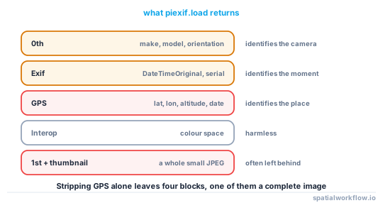
The metadata also carries a timestamp, a camera make and model, and often a serial number. Together those link photographs across datasets and identify the photographer as reliably as the coordinates identify the subject.
This guide reads the tags, removes the ones that matter, and verifies the removal, with the specific traps: Pillow re-saves that recompress, tools that leave a thumbnail with its own EXIF, and formats that hide location somewhere other than EXIF.
Quick answer
import piexif

# Read what is there
tags = piexif.load("photo.jpg")
print("GPS tags:", len(tags["GPS"]))

# Remove only GPS, keep the rest
tags["GPS"] = {}
piexif.insert(piexif.dump(tags), "photo.jpg")

# Or remove all EXIF
piexif.remove("photo.jpg")
piexif.insert rewrites the metadata block in place without touching the image data, so the pixels are bit-identical and there is no generation loss. In a round-trip test, a JPEG with six GPS tags came back with zero after the strip, the camera model survived as intended, and the file stayed 391 KB.
Step-by-step solution
1. Audit before you strip
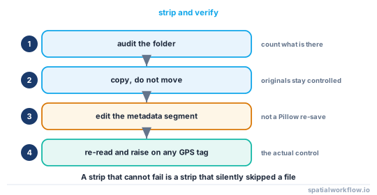
Know what is in the folder. Count files with GPS tags, with a serial number, and with a timestamp, so the report says what was removed rather than what you hoped was there.
2. Decide between removing GPS and removing everything
Removing only GPS keeps the camera, the lens and the date, which are useful for provenance and are usually not sensitive. Removing everything is safer and loses the evidence trail. For a public release, remove everything and keep the originals in a controlled location with a manifest.
3. Convert GPS tags correctly if you need to read them first
EXIF stores latitude and longitude as three rationals — degrees, minutes, seconds — plus a hemisphere reference. Forgetting the reference gives you a point in the wrong hemisphere.
def to_degrees(triple, ref):
    d, m, s = (a / b for a, b in triple)
    value = d + m / 60 + s / 3600
    return -value if ref in (b"S", b"W") else value
4. Strip in place, not by re-saving
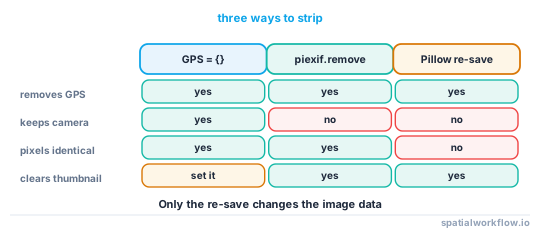
piexif.insert and piexif.remove edit the metadata segment. Opening with Pillow and calling save re-encodes the JPEG — it does drop EXIF, which a test confirms, but it also recompresses the image and changes every pixel.
5. Check for a thumbnail
The 1st IFD holds an embedded thumbnail, which is a complete small JPEG that can have its own metadata. Some strippers leave it. piexif.remove clears the whole block.
6. Verify, do not assume
Re-read every file after the pass and fail loudly on any remaining GPS tag. A stripper that silently skipped an unreadable file is worse than no stripper.
7. Handle the other formats
HEIC, PNG, TIFF and WebP all have metadata containers, and some carry location in XMP rather than EXIF. Convert or use a tool that understands the container; a JPEG-only pass on a mixed folder leaves the HEICs untouched.
8. Check the filenames and the folder structure
IMG_20260411_Riverside_Close.jpg is a location. So is a folder named after a household.
Code examples
Example 1 — audit a folder
import pathlib, piexif

def audit(folder):
    rows = []
    for p in sorted(pathlib.Path(folder).glob("**/*.jpg")):
        try:
            tags = piexif.load(str(p))
        except Exception as exc:
            rows.append({"file": p.name, "error": str(exc)})
            continue
        rows.append({
            "file": p.name,
            "gps_tags": len(tags["GPS"]),
            "has_datetime": piexif.ExifIFD.DateTimeOriginal in tags["Exif"],
            "make_model": (tags["0th"].get(piexif.ImageIFD.Make, b"").decode(errors="replace"),
                           tags["0th"].get(piexif.ImageIFD.Model, b"").decode(errors="replace")),
            "thumbnail": tags["thumbnail"] is not None,
        })
    return rows
Example 2 — read the coordinates, then remove them
import piexif

tags = piexif.load("photo.jpg")
gps = tags["GPS"]

def to_degrees(triple, ref):
    d, m, s = (a / b for a, b in triple)
    value = d + m / 60 + s / 3600
    return -value if ref in (b"S", b"W") else value

lat = to_degrees(gps[piexif.GPSIFD.GPSLatitude], gps[piexif.GPSIFD.GPSLatitudeRef])
lon = to_degrees(gps[piexif.GPSIFD.GPSLongitude], gps[piexif.GPSIFD.GPSLongitudeRef])
print(f"{lat:.6f}, {lon:.6f}")

tags["GPS"] = {}
piexif.insert(piexif.dump(tags), "photo.jpg")
print("GPS tags after:", len(piexif.load("photo.jpg")["GPS"]))
50.822531, -0.137164
GPS tags after: 0
The camera model survived the strip, which is what tags["GPS"] = {} promises; piexif.remove clears all five blocks instead.
Example 3 — strip a folder and fail on anything left behind
import pathlib, piexif, shutil

def strip_folder(src, dst, keep_camera=False):
    src, dst = pathlib.Path(src), pathlib.Path(dst)
    dst.mkdir(parents=True, exist_ok=True)
    report = []
    for p in sorted(src.glob("**/*.jpg")):
        out = dst / p.name
        shutil.copy2(p, out)
        if keep_camera:
            tags = piexif.load(str(out))
            before = len(tags["GPS"])
            tags["GPS"] = {}
            tags["thumbnail"] = None
            piexif.insert(piexif.dump(tags), str(out))
        else:
            before = len(piexif.load(str(out))["GPS"])
            piexif.remove(str(out))
        after = len(piexif.load(str(out))["GPS"])
        report.append({"file": p.name, "gps_before": before, "gps_after": after})

    leaks = [r for r in report if r["gps_after"]]
    if leaks:
        raise RuntimeError(f"{len(leaks)} file(s) still carry GPS tags: "
                           f"{[r['file'] for r in leaks][:5]}")
    return report
Raising is the point. A stripping pass that reports success on files it failed to open is the failure this whole guide is about.
Explanation
Why EXIF survives so much handling
The metadata block is separate from the compressed image data, so copying, moving, uploading and most resizing preserve it. Social platforms usually strip it on upload, which is why people believe it is fragile; a file handed over on a drive or in a zip keeps everything.
Why re-saving through Pillow is a poor strip
Image.open(p).save(q) does drop EXIF unless you pass it explicitly — a test on a stripped file confirmed no exif key remained. But it re-encodes the JPEG at whatever quality you specify, which loses detail, changes the file size and breaks any checksum-based provenance you were keeping. Edit the metadata segment instead.
Why timestamps matter as much as coordinates
A photograph taken at a known time and place is a strong quasi-identifier even without coordinates, because it can be matched against anything else that happened then. For survey work, the date is often needed; the time to the second rarely is. Coarsen it rather than deleting it if provenance matters.
Why the folder is part of the release
Photographs are usually shipped alongside the vector data, and the two are checked by different people. If the points were masked, the photographs have to move with them: either strip the coordinates, or re-tag the photograph with the masked coordinate so the two agree.
Edge cases or notes
- HEIC and PNG have their own containers. A JPEG-only pass leaves them intact.
- XMP can duplicate the location. Some cameras and editors write both.
- Thumbnails carry metadata. Clear the
1stIFD as well asGPS. - Filenames and folders leak. Rename on export.
- Altitude is a GPS tag too. Removing latitude and longitude alone leaves
GPSAltitude. - Faces and signage leak. Metadata stripping does not touch the pixels.
- Keep the originals. In a controlled place, with a manifest linking them to the released copies.
- Run the strip in the pipeline, not by hand. A manual step is a step that gets skipped.
Internal links
- How to run a privacy check before publishing a spatial dataset — the gate that should be calling this
- A shared file still contains the original coordinates — the other side channels
- Geoprivacy explained: why coordinates are personal data — why photograph coordinates are the same problem
- How to apply donut geomasking to sensitive points in Python — keeping photographs consistent with masked points
- How to build a GIS folder inventory and manifest in Python — the manifest for the originals
- How to package GIS deliverables in Python — what goes in the zip
- How to checksum spatial datasets so you can prove they match — why re-encoding breaks provenance
- How to standardise dates in spatial data with Python — coarsening timestamps
FAQ
How do I remove GPS data from a photo in Python?
Load the tags with piexif.load, set tags["GPS"] = {} and write them back with piexif.insert, or call piexif.remove to clear every metadata block.
Does saving the image again remove EXIF?
Pillow drops EXIF on save unless you pass it explicitly, but it also re-encodes the image. Editing the metadata segment in place keeps the pixels identical.
Will stripping EXIF change the image?
Not with piexif.insert or piexif.remove. Both rewrite only the metadata segment.
What else in a photo is identifying?
The timestamp, camera make, model and serial number, an embedded thumbnail, the filename, the folder name, and whatever is visible in the picture.
Do HEIC and PNG files have the same problem?
Yes, in different containers, and some store location in XMP rather than EXIF. A JPEG-only pass will silently skip them.
Should I delete the originals?
No. Keep them somewhere controlled with a manifest; you will need them to answer questions about the release later.