
How to Read the World Port Index in Python
On this page
Problem statement
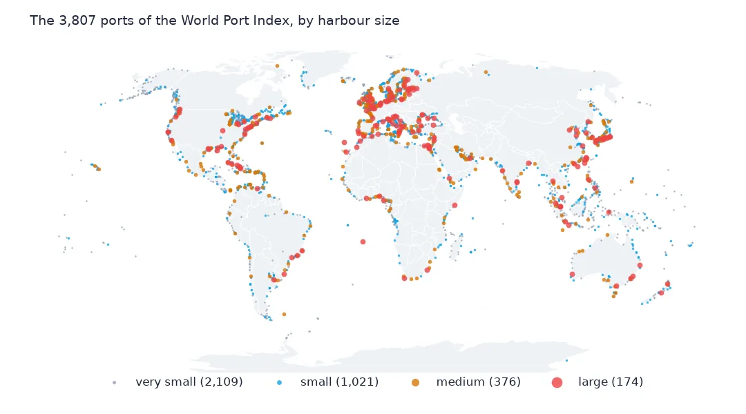
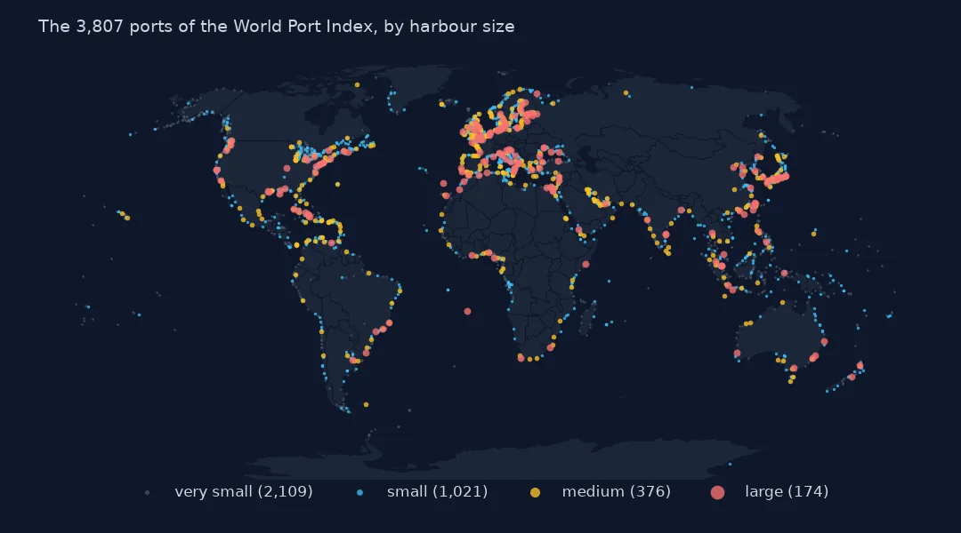
The World Port Index, published by the US National Geospatial-Intelligence Agency, is the standard open list of the world's ports: 3,807 of them, each with its position, country, harbour size and type, depths, tides, the restrictions on entering, and 73 yes-or-no questions about its facilities, services and supplies. It is the reference behind most maps of ports and many shipping studies. Its CSV is 109 columns wide, and three conventions make it misleading if read as it comes: empty cells written as a single space, zeros where a measurement is unknown, and "Unknown" as a third answer to every yes-or-no question. This page reads it and handles each.
Quick answer
Read the CSV, which starts with a byte-order mark, and look at the first rows and the column types:
print(wpi[["World Port Index Number", "Main Port Name", "Country Code", "Harbor Size", "Harbor Type", "Latitude", "Longitude"]].head(3).to_string(index=False))
print(wpi.dtypes.value_counts().to_dict())
World Port Index Number Main Port Name Country Code Harbor Size Harbor Type Latitude Longitude
7950.0 Maurer United States Very Small River (Natural) 40.533333 -74.250000
47620.0 Iharana Madagascar Very Small Coastal (Natural) -13.350000 50.000000
47020.0 Chake Chake Tanzania Small Coastal (Natural) -5.250000 39.766667
{<StringDtype(na_value=nan)>: 92, dtype('float64'): 17}
The rows are in no useful order: Maurer, a very small river port in New Jersey, comes first, then Iharana in Madagascar and Chake Chake in Tanzania. 92 columns are read as text and only 17 as numbers. The World Port Index Number comes back as a float, 7950.0, because pandas reads the whole column as numbers.
Blanks, zeros, flags and ids
1. Blank cells that are a space
print(f"cells holding a single space: {(wpi == ' ').sum().sum():,}; columns with any: {(wpi == ' ').any().sum()}")
print(wpi["Harbor Size"].value_counts(dropna=False).to_dict())
wpi = wpi.replace(r"^\s*$", np.nan, regex=True)
cells holding a single space: 16,106; columns with any: 10
{'Very Small': 2109, 'Small': 1021, 'Medium': 376, 'Large': 174, ' ': 127}
16,106 cells across 10 columns hold a single space instead of being empty, so isna() finds nothing and a value count shows " " as a category: 127 ports have a harbour size of " ". Replacing whitespace-only cells with missing values fixes every column at once.
2. Numbers, and zeros that mean unknown
DEPTHS = [c for c in wpi.columns if c.endswith("(m)")]
print(f"measurement columns: {len(DEPTHS)}")
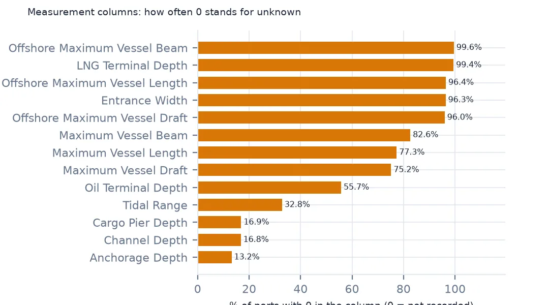
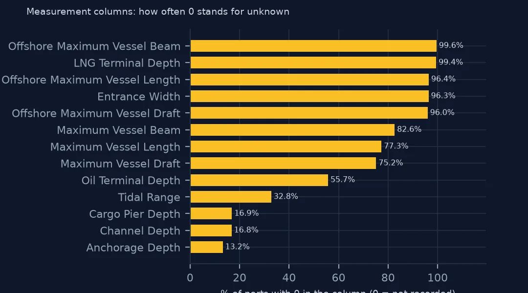
print((wpi[DEPTHS] == 0).mean().sort_values().round(3).iloc[[0, 1, -2, -1]].to_string())
measurement columns: 13
Anchorage Depth (m) 0.132
Channel Depth (m) 0.168
Liquified Natural Gas Terminal Depth (m) 0.994
Offshore Maximum Vessel Beam (m) 0.996
13 columns hold measurements in metres, and a zero in them means "not recorded", not zero metres. 13.2% of anchorage depths and 16.8% of channel depths are 0, and the offshore vessel limits are 0 for 99.6% of ports. Treat 0 as missing before any average, as the zeros page shows.
3. Yes, No and Unknown
flags = [c for c in wpi.columns if set(wpi[c].dropna().unique()) <= {"Yes", "No", "Unknown"}]
print(f"Yes/No/Unknown columns: {len(flags)}")
print(wpi[flags].apply(lambda s: s.eq("Unknown").mean()).describe().round(3).loc[["min", "50%", "max"]].to_string())
Yes/No/Unknown columns: 73
min 0.000
50% 0.645
max 0.997
73 columns answer yes or no, and every one has "Unknown" as a third value. The median column is 64.5% Unknown, and one is Unknown for 99.7% of ports. Reading these as booleans turns Unknown into No.
4. Ids and points
print(f"index numbers unique: {wpi['World Port Index Number'].is_unique}; duplicated: {wpi['World Port Index Number'].duplicated(keep=False).sum()}")
print(f"UN/LOCODE given: {wpi['UN/LOCODE'].notna().sum():,}; coordinates missing: {wpi.Latitude.isna().sum()}")
ports = gpd.GeoDataFrame(wpi, geometry=gpd.points_from_xy(wpi.Longitude, wpi.Latitude), crs=4326)
print(ports.total_bounds.round(1).tolist())
index numbers unique: False; duplicated: 4
UN/LOCODE given: 3,348; coordinates missing: 0
[-177.4, -77.8, 179.4, 78.9]
The index number is not unique: 4 ports share 2 numbers, a duplicate of Seydisfjordur in Iceland under two spellings and two Nigerian ports. 3,348 ports have a UN/LOCODE, the code used in trade data, and every port has coordinates, from 177.4° W to 179.4° E and from McMurdo Station at 77.8° S to 78.9° N in the Arctic.
Ports by country and harbour type
The data used on this page
The US National Geospatial-Intelligence Agency's World Port Index (Pub. 150), the CSV served by its Maritime Safety Information site, downloaded on 28 October 2026 and saved on this site, because NGA revises the index as port information changes. A US government publication, free to use. Depths and lengths are in metres.
from pathlib import Path
import zipfile

import geopandas as gpd
import numpy as np
import pandas as pd
import requests

Path("data").mkdir(exist_ok=True)
# NGA's World Port Index (Pub. 150) as CSV, with Natural Earth's populated places, countries and land. Saved
# 28 October 2026: NGA revises the index as port information changes.
# Live: https://msi.nga.mil/api/publications/download?type=view&key=16920959/SFH00000/UpdatedPub150.csv
ARCHIVE = "nga-world-port-index-2026-10-28.zip"
if not Path(f"data/{ARCHIVE}").exists():
    Path(f"data/{ARCHIVE}").write_bytes(requests.get(f"https://data.spatialworkflow.io/{ARCHIVE}", timeout=600).content)
Z = zipfile.ZipFile(f"data/{ARCHIVE}")
for f in ["ne_10m_populated_places_simple.zip", "ne_110m_admin_0_countries.zip", "ne_50m_land.zip"]:
    Path(f"data/{f}").write_bytes(Z.read(f))
wpi = pd.read_csv(Z.open("UpdatedPub150.csv"), encoding="utf-8-sig")
print(f"World Port Index: {len(wpi):,} ports, {wpi.shape[1]} columns")
World Port Index: 3,807 ports, 109 columns
Example 1: ports by country
print(wpi["Country Code"].value_counts().head(8).to_string())
print(f"countries and territories: {wpi['Country Code'].nunique()}")
Country Code
United States 666
Canada 285
United Kingdom 186
Japan 163
Norway 141
Indonesia 123
Italy 123
Sweden 92
countries and territories: 195
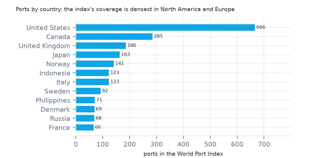
The United States has the most ports in the index, 666, then Canada with 285, the United Kingdom 186, Japan 163 and Norway 141. North American and northern European waters are listed in far more detail than most of Africa and Asia, so a count of ports by country measures the index's coverage as much as the coastline.
Example 2: harbour size and type
print(pd.crosstab(wpi["Harbor Type"], wpi["Harbor Size"])[["Very Small", "Small", "Medium", "Large"]].to_string())Harbor Size Very Small Small Medium Large
Harbor Type
Canal or Lake 26 29 11 6
Coastal (Breakwater) 347 250 124 71
Coastal (Natural) 821 304 93 33
Coastal (Tide Gates) 5 18 9 2
Open Roadstead 497 121 33 12
River (Basins) 32 35 12 8
River (Natural) 362 198 77 29
River (Tide Gates) 13 16 16 10
Typhoon Harbor 3 1 0 0
By type and size, natural coastal harbours are the most common very small ports, 821, while harbours protected by breakwaters supply the most large ones, 71. Open roadsteads, anchorages off an open coast, are mostly very small. River ports with tide gates are few, but nearly half of them, 16 medium and 10 large, are big ports.
Internal links
- The World Port Index explained — what it counts and records, and getting the data without code
- Depths stored as 0 — the measurement columns' trap
- Yes, No and Unknown — the flag columns' trap
- Ports by country — the ports on a map