
How to Find the Ports Where Ice Restricts Entry
On this page
Problem statement
Which ports does ice close or restrict in winter? The World Port Index answers for each port in Entrance Restriction - Ice: yes, no or unknown. The answer follows latitude, but not neatly: the Gulf Stream keeps Norway's Arctic ports open, while the Great Lakes, the Gulf of Bothnia and the Bo Hai freeze far further south. This page counts ice-restricted ports by latitude and country, finds the ice ports in the southern hemisphere and the northernmost ice-free ones, and checks which ports offer ice-breaking.
Quick answer
Count the ice answers and their shares by band of latitude:
ice = ports["Entrance Restriction - Ice"]
print(ice.value_counts(dropna=False).to_string())
band = pd.cut(ports.Latitude.abs(), [0, 30, 40, 50, 60, 70, 90])
print(pd.crosstab(band, ice, normalize="index").round(3).to_string())
Entrance Restriction - Ice
No 2053
Unknown 1132
Yes 622
Entrance Restriction - Ice No Unknown Yes
Latitude
(0, 30] 0.578 0.419 0.003
(30, 40] 0.621 0.352 0.027
(40, 50] 0.408 0.221 0.371
(50, 60] 0.641 0.177 0.182
(60, 70] 0.394 0.202 0.404
(70, 90] 0.393 0.107 0.500
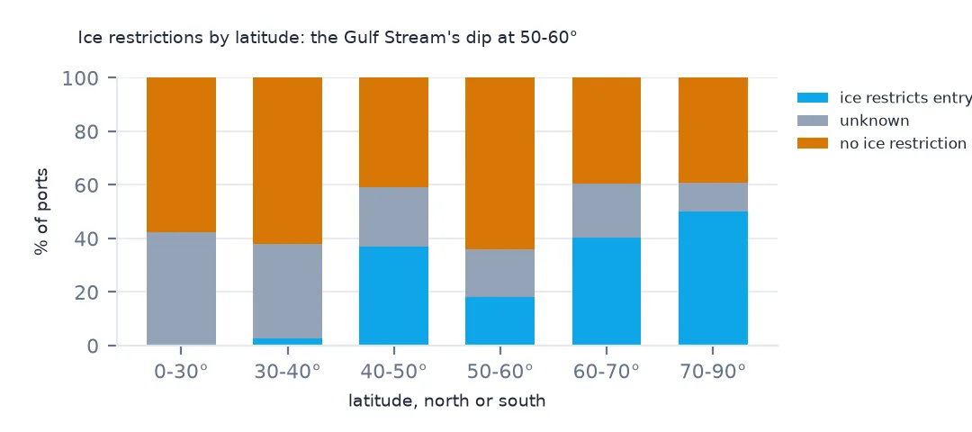
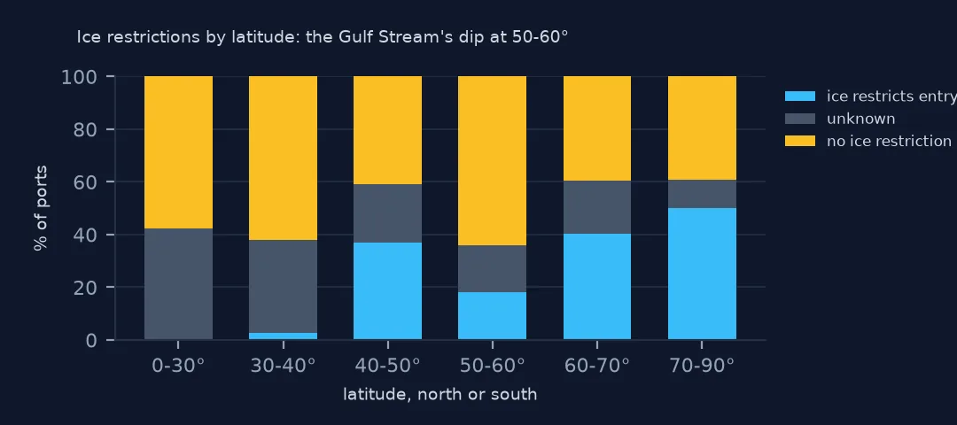
622 ports are restricted by ice, 2,053 are not and 1,132 are unknown. Below 30° of latitude almost none are, 0.3%, and between 30° and 40° 2.7%. The share jumps to 37.1% between 40° and 50°, falls to 18.2% between 50° and 60°, and rises again to 40.4% and 50.0% further north. The dip between 50° and 60° is the North Sea and the Norwegian coast, kept open by the warm Atlantic water of the Gulf Stream.
Countries, the south and the far north
1. By country
yes = ports[ice == "Yes"]
print(yes["Country Code"].value_counts().head(8).to_string())
Country Code
United States 167
Canada 154
Russia 49
Sweden 43
Finland 25
Denmark 23
Norway 22
Ukraine 19
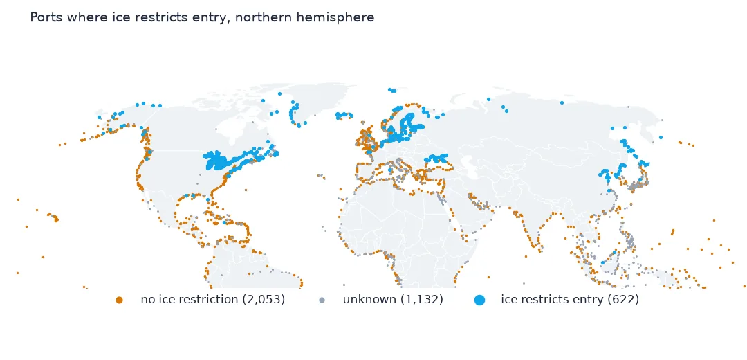
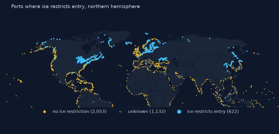
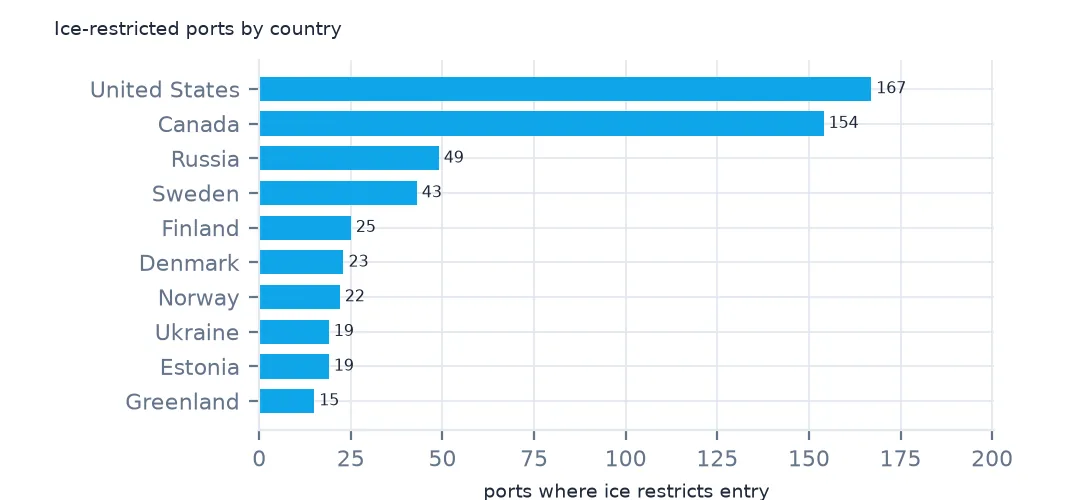
The United States has the most ice-restricted ports, 167, and Canada 154: the Great Lakes, the St. Lawrence, New England and Alaska. Russia follows with 49, then Sweden, Finland and Denmark on the Baltic, Norway's northern ports and Ukraine's on the Black Sea and the Sea of Azov.
2. Ice in the south
s = ports[(ports.Latitude < 0) & (ice == "Yes")]
print(s[["Main Port Name", "Country Code", "Latitude"]].sort_values("Latitude").head(5).round(1).to_string(index=False))
Main Port Name Country Code Latitude
Mcmurdo Station Antarctica -77.8
Port Lockroy Antarctica -64.8
Andersen Harbor Antarctica -64.3
Melchior Harbor Antarctica -64.3
Port Foster Antarctica -63.0
South of the equator, ice restricts only Antarctic harbours in the index: McMurdo Station at 77.8° S, and Port Lockroy, Andersen Harbor, Melchior Harbor and Port Foster in the Antarctic Peninsula and the South Shetlands, between 63° and 65° S. No inhabited southern continent has ice-bound ports.
3. The furthest south and north without ice
no = ports[ice == "No"]
print(no.nlargest(3, "Latitude")[["Main Port Name", "Country Code", "Latitude"]].round(1).to_string(index=False))
print(f"ice-restricted ports below 45° N in the northern hemisphere: {((ports.Latitude.between(0, 45)) & (ice == 'Yes')).sum()}")
Main Port Name Country Code Latitude
Honningsvag Norway 71.0
Kjollefjorden Norway 71.0
Berlevag Norway 70.9
ice-restricted ports below 45° N in the northern hemisphere: 203
The northernmost ports recorded as free of ice are Norwegian, Honningsvåg and Kjøllefjord at 71.0° N and Berlevåg at 70.9° N, north of the Arctic Circle and open all winter. In the other direction, 203 ice-restricted ports in the northern hemisphere lie south of 45° N, most on the Great Lakes, then the North Atlantic coast of North America, the Sea of Japan and the Bo Hai gulf of northern China.
Ice-breaking services
The data used on this page
The US National Geospatial-Intelligence Agency's World Port Index (Pub. 150), the CSV served by its Maritime Safety Information site, downloaded on 28 October 2026 and saved on this site, because NGA revises the index as port information changes. A US government publication, free to use. Depths and lengths are in metres.
from pathlib import Path
import zipfile

import geopandas as gpd
import numpy as np
import pandas as pd
import requests

Path("data").mkdir(exist_ok=True)
# NGA's World Port Index (Pub. 150) as CSV, with Natural Earth's populated places, countries and land. Saved
# 28 October 2026: NGA revises the index as port information changes.
# Live: https://msi.nga.mil/api/publications/download?type=view&key=16920959/SFH00000/UpdatedPub150.csv
ARCHIVE = "nga-world-port-index-2026-10-28.zip"
if not Path(f"data/{ARCHIVE}").exists():
    Path(f"data/{ARCHIVE}").write_bytes(requests.get(f"https://data.spatialworkflow.io/{ARCHIVE}", timeout=600).content)
Z = zipfile.ZipFile(f"data/{ARCHIVE}")
for f in ["ne_10m_populated_places_simple.zip", "ne_110m_admin_0_countries.zip", "ne_50m_land.zip"]:
    Path(f"data/{f}").write_bytes(Z.read(f))
wpi = pd.read_csv(Z.open("UpdatedPub150.csv"), encoding="utf-8-sig")
wpi = wpi.replace(r"^\s*$", np.nan, regex=True)                                  # blank cells are a single space
DEPTHS = [c for c in wpi.columns if c.endswith("(m)")]
wpi[DEPTHS] = wpi[DEPTHS].where(wpi[DEPTHS] > 0)                                    # 0 means not recorded
ports = gpd.GeoDataFrame(wpi, geometry=gpd.points_from_xy(wpi.Longitude, wpi.Latitude), crs=4326)
print(f"World Port Index: {len(ports):,} ports in {ports['Country Code'].nunique()} countries and territories")
World Port Index: 3,807 ports in 195 countries and territories
Example 1: ice-breaking services
print(pd.crosstab(ice, ports["Services - Ice Breaking"]).to_string())Services - Ice Breaking No Unknown Yes
Entrance Restriction - Ice
No 11 2042 0
Unknown 2 1130 0
Yes 9 601 12
Ice-breaking is recorded as available at only 12 ports, all of them ice-restricted, and as unavailable at 9; for 601 of the 622 ice ports it is unknown. The index can say where ice is a problem; it cannot say where help is.
Internal links
- Snow and ice — sea ice and snow cover in data
- Ports by sea — the water bodies these ports are on
- Yes, No and Unknown — the third answer in this column
- Reading the index — the restriction columns