
Fixing School Maps Distorted by Virtual Schools
On this page
Problem statement
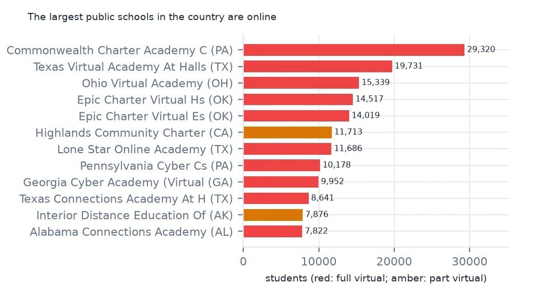
Sort NCES's school file by enrolment and the largest public schools in the country are not schools anyone walks into. Commonwealth Charter Academy, 29,320 students, has its address in Harrisburg, Pennsylvania; Texas Virtual Academy, 19,731, in Hallsville. Full-time online schools enrol students across a whole state and report them at one office, so on a map every one of those students appears in a single county. A map of students per county or the size of the largest school then shows a virtual school, not the place. This page finds the virtual schools, measures how much they distort county totals, and catches the ones the flag misses.
Quick answer
Rank schools by enrolment and count the full-time virtual ones:
print(sch.nlargest(6, "TOTAL")[["SCH_NAME", "LCITY", "LSTATE", "VIRTUAL", "TOTAL"]].to_string(index=False))
fv = sch[sch.VIRTUAL == "Full Virtual"]
print(f"full-virtual schools: {len(fv):,} with {fv.TOTAL.sum():,.0f} students ({fv.TOTAL.sum() / sch.TOTAL.sum():.1%})")
SCH_NAME LCITY LSTATE VIRTUAL TOTAL
Commonwealth Charter Academy CS Harrisburg PA Full Virtual 29320.0
TEXAS VIRTUAL ACADEMY AT HALLSVILLE HALLSVILLE TX Full Virtual 19731.0
Ohio Virtual Academy Maumee OH Full Virtual 15339.0
EPIC CHARTER VIRTUAL HS Oklahoma City OK Full Virtual 14517.0
EPIC CHARTER VIRTUAL ES Oklahoma City OK Full Virtual 14019.0
Highlands Community Charter Sacramento CA Supplemental Virtual 11713.0
full-virtual schools: 1,223 with 611,897 students (1.2%)
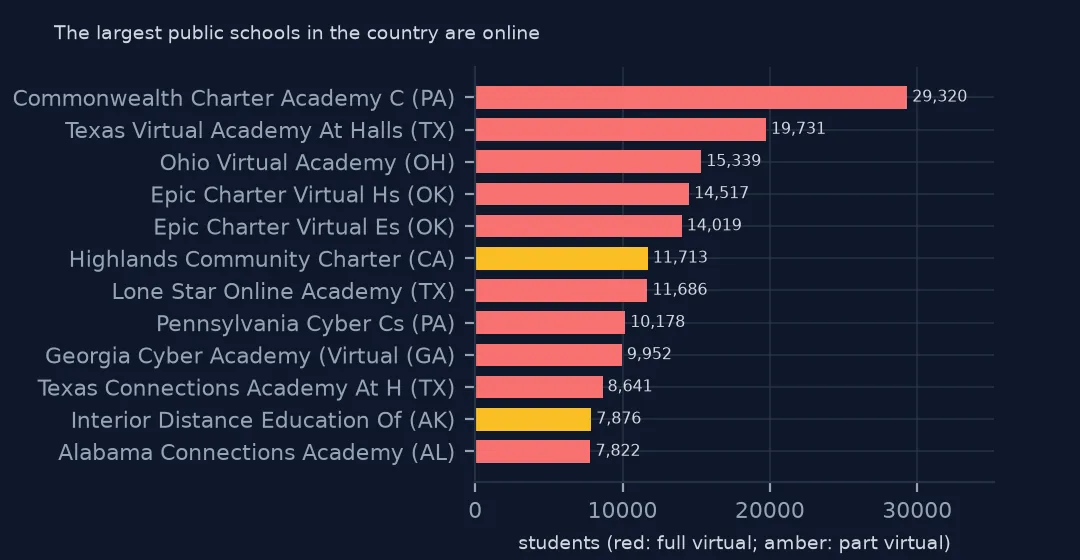
The five largest schools in the file are all full-time virtual, and the sixth, Highlands Community Charter in Sacramento, is flagged supplemental virtual. In all, 1,223 full-virtual schools enrol 611,897 students, 1.2% of the national total, a small share that is concentrated in a few addresses.
Where virtual students land, and how to find them
1. Where the virtual students are counted
counties = gpd.read_file("data/cb_2024_us_county_20m.zip")
cc = sch.groupby("CNTY").TOTAL.sum().rename("all").to_frame().join(fv.groupby("CNTY").TOTAL.sum().rename("virtual")).fillna(0)
cc["share"] = cc.virtual / cc["all"]
top = cc[cc["all"] > 10_000].sort_values("share", ascending=False).head(6).join(counties.set_index("GEOID")[["NAME", "STUSPS"]])
print(top[["NAME", "STUSPS", "all", "virtual", "share"]].round(3).to_string())
NAME STUSPS all virtual share
CNTY
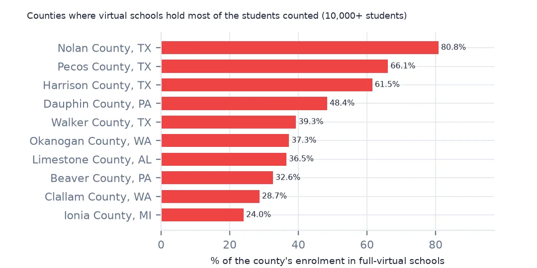
48353 Nolan TX 14455.0 11686.0 0.808
48371 Pecos TX 14033.0 9278.0 0.661
48203 Harrison TX 32062.0 19731.0 0.615
42043 Dauphin PA 72394.0 35041.0 0.484
48471 Walker TX 12523.0 4924.0 0.393
53047 Okanogan WA 11538.0 4299.0 0.373
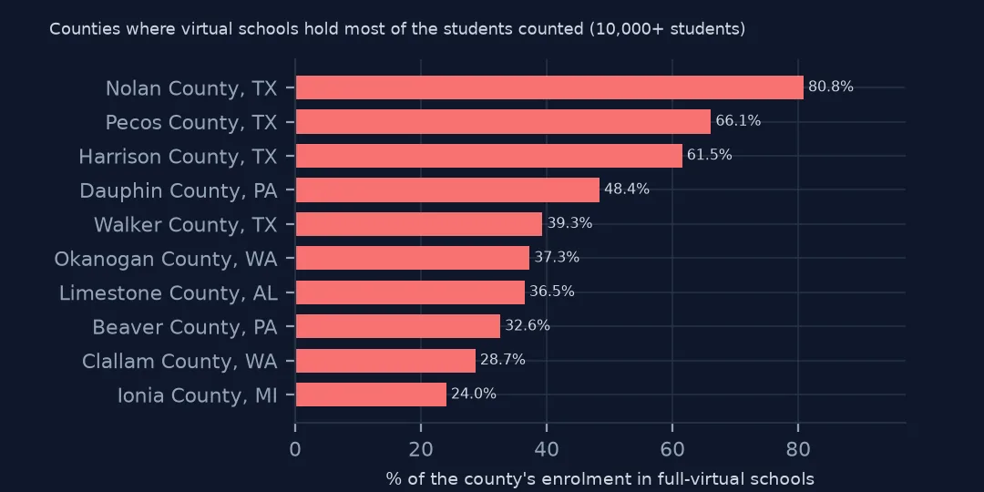
In counties with more than 10,000 students, the distortion is largest in rural Texas. In Nolan County, 80.8% of the students counted are enrolled in full-time virtual schools based there, and in Pecos County 66.1%. In Harrison County, the home of Texas Virtual Academy at Hallsville, it is 61.5%, and in Dauphin County, Pennsylvania, 48.4%. Mapped as students per county, these places look like school districts several times their real size.
2. The VIRTUAL column
print(sch.groupby("VIRTUAL").TOTAL.agg(["size", "sum", "median"]).astype(int).to_string())
print(sch[sch.VIRTUAL == "M"].LSTATE.value_counts().head(4).to_dict())
size sum median
VIRTUAL
Full Virtual 1223 611897 84
M 10222 5797363 484
Not Virtual 71039 33781621 400
Supplemental Virtual 17235 8957535 418
Virtual with face to face options 518 195108 117
{'TX': 9166, 'ID': 795, 'CA': 224, 'AS': 28}
The VIRTUAL column has five values plus M, missing. M covers 10,222 schools with 5,797,363 students, and almost all of them are in Texas, 9,166 schools, then Idaho and California. For those states the flag cannot be used on its own, and the few Texas schools that do carry one cannot stand for the rest.
3. Name says virtual, flag says not
named = sch.SCH_NAME.str.contains(r"\b(?:virtual|online|cyber|e-?academy|digital)\b", case=False, regex=True)
print(sch[named].VIRTUAL.value_counts().to_string())
print(sch[named & (sch.VIRTUAL == "M")].nlargest(3, "TOTAL")[["SCH_NAME", "LSTATE", "TOTAL"]].to_string(index=False))
VIRTUAL
Full Virtual 895
Virtual with face to face options 156
Not Virtual 74
M 27
Supplemental Virtual 18
SCH_NAME LSTATE TOTAL
IDAHO VIRTUAL ACADEMY ID 1801.0
SNAKE RIVER ONLINE ID 1750.0
iSUCCEED VIRTUAL HIGH SCHOOL ID 1290.0
The name catches what the flag misses. Of the schools with virtual, online, cyber or digital in their name, 895 are flagged full virtual, but 27 have no flag at all, including Idaho Virtual Academy with 1,801 students and Snake River Online with 1,750, and 74 are flagged as not virtual. Use the flag where it exists and the name where it doesn't, and check the largest schools in each state by hand.
County totals with and without
The data used on this page
NCES's Public School Characteristics layer from the Education Demographic and Geographic Estimates (EDGE) program: the 2024-25 Common Core of Data on EDGE's school points, every record of its ArcGIS service, downloaded on 28 October 2026 and saved on this site, because the "Current" layer is replaced each school year. Public domain. Counts are headcounts reported by state education agencies; teachers are full-time equivalents. County boundaries are the Census Bureau's 2024 cartographic boundary file, public domain.
from pathlib import Path
import zipfile

import geopandas as gpd
import numpy as np
import pandas as pd
import requests

Path("data").mkdir(exist_ok=True)
# NCES EDGE "Public School Characteristics" for 2024-25 (the Common Core of Data on EDGE's school points), EDGE's school
# neighborhood poverty estimates for 2021-22, and the Census Bureau's 2024 counties and states. Saved 28 October 2026:
# the "Current" layers are replaced every school year.
# Live: https://services1.arcgis.com/Ua5sjt3LWTPigjyD/arcgis/rest/services/School_Characteristics_Current/FeatureServer/1
ARCHIVE = "nces-schools-2026-10-28.zip"
if not Path(f"data/{ARCHIVE}").exists():
    Path(f"data/{ARCHIVE}").write_bytes(requests.get(f"https://data.spatialworkflow.io/{ARCHIVE}", timeout=600).content)
Z = zipfile.ZipFile(f"data/{ARCHIVE}")
sch = pd.read_csv(Z.open("school-characteristics-2024-25.csv"), dtype={"NCESSCH": str, "LEAID": str, "CNTY": str, "LZIP": str, "LSTREET2": str})
for f in ["cb_2024_us_county_20m.zip", "cb_2024_us_state_20m.zip"]:
    Path(f"data/{f}").write_bytes(Z.read(f))
print(f"NCES public schools 2024-25: {len(sch):,} records")
sch["LSTATE"] = sch.LSTATE.str.strip()                                    # stored padded to three characters
NUM = ["TOTAL", "FTE", "STUTERATIO", "TOTFRL", "FRELCH", "REDLCH", "DIRECTCERT", "AM", "AS_", "BL", "HP", "HI", "TR", "WH"]
sch[NUM] = sch[NUM].where(sch[NUM] >= 0)                                  # -1 missing, -2 not applicable, -9 below quality standards
sch = sch[sch.SY_STATUS_TEXT.isin(["Open", "New", "Reopened", "Added", "Changed Boundary/Agency"])]
print(f"operating schools: {len(sch):,}; students: {sch.TOTAL.sum():,.0f}")
NCES public schools 2024-25: 101,110 records
operating schools: 100,237; students: 49,343,524
Example 1: students per school in a county, with and without
inp = sch[~sch.VIRTUAL.isin(["Full Virtual"])]
for geoid in ["42043", "39095", "40109"]:
    a, b = sch[sch.CNTY == geoid], inp[inp.CNTY == geoid]
    print(geoid, counties.set_index("GEOID").NAME.get(geoid), f"students {a.TOTAL.sum():,.0f} -> {b.TOTAL.sum():,.0f}; largest school {a.TOTAL.max():,.0f} -> {b.TOTAL.max():,.0f}")
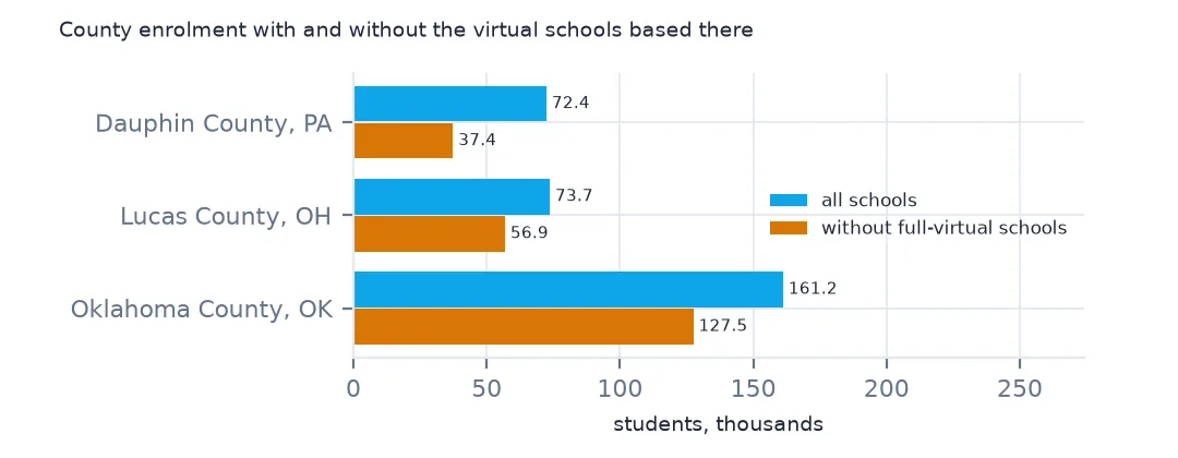
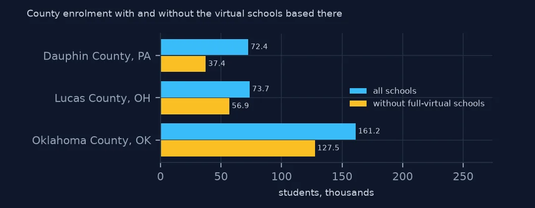
42043 Dauphin students 72,394 -> 37,353; largest school 29,320 -> 1,966
39095 Lucas students 73,661 -> 56,859; largest school 15,339 -> 2,113
40109 Oklahoma students 161,162 -> 127,472; largest school 14,517 -> 2,774
Taking the full-virtual schools out changes the county figures completely. Dauphin County's students fall from 72,394 to 37,353 and its largest school from 29,320 to 1,966. Lucas County, Ohio, home of Ohio Virtual Academy, falls from 73,661 to 56,859, and Oklahoma County from 161,162 to 127,472. For a map of where children go to school, drop the virtual schools or show them as a separate statewide layer; for a state total, keep them.
Internal links
- Students per school by county — the map this fix protects
- Charter schools by state — most virtual schools are charters
- Student-teacher ratios — ratios that virtual schools stretch
- Codes of -1, -2 and -9 — the M and N in the virtual column