
How to Read NCES Public School Data in Python
On this page
Problem statement
The National Center for Education Statistics (NCES) publishes a record for every public school in the United States: 101,110 rows for 2024-25, each with its name, district, address, grades, level, locale, enrolment, teachers, free-lunch counts and students by race, and a point location from NCES's EDGE program. It is the standard source for any map or count of American schools. It also carries traps that a first read misses: state codes padded with a space, rows for schools that have closed or not yet opened, and the numbers -1, -2 and -9 in count columns. This page reads it, checks the ids and statuses, and builds points.
Quick answer
Strip the padded state codes and build points from LONCOD and LATCOD, which are in NAD83:
sch["LSTATE"] = sch.LSTATE.str.strip()
g = gpd.GeoDataFrame(sch, geometry=gpd.points_from_xy(sch.LONCOD, sch.LATCOD), crs=4269)
print(g[["NCESSCH", "SCH_NAME", "LCITY", "LSTATE", "SCHOOL_LEVEL", "TOTAL", "FTE"]].head(3).to_string(index=False))
print(f"{len(g):,} schools in {g.LSTATE.nunique()} states and territories")
NCESSCH SCH_NAME LCITY LSTATE SCHOOL_LEVEL TOTAL FTE
010000500870 Albertville Middle School Albertville AL Middle 849 43.0
010000500871 Albertville High School Albertville AL High 1244 66.5
010000500879 Albertville Intermediate School Albertville AL Middle 843 42.0
101,110 schools in 56 states and territories
The first rows are schools in Albertville, Alabama: a middle school of 849 students with 43 full-time-equivalent teachers, a high school of 1,244 with 66.5. The file has 101,110 schools in 56 states and territories: the 50 states, DC, Puerto Rico and four island territories. LSTATE is stored as three characters, "AL " with a trailing space, so a filter on "AL" matches nothing until it is stripped.
Reading the file
1. Ids
print(f"NCESSCH unique: {sch.NCESSCH.is_unique}; lengths: {sch.NCESSCH.str.len().value_counts().to_dict()}")
print(f"NCESSCH starts with LEAID: {(sch.NCESSCH.str[:7] == sch.LEAID).mean():.1%}; districts: {sch.LEAID.nunique():,}")
NCESSCH unique: True; lengths: {12: 101110}
NCESSCH starts with LEAID: 100.0%; districts: 18,495
NCESSCH, the 12-digit school id, is unique and always begins with the 7-digit LEAID of the school's district, so the district can be read from the school id. Read both as strings: as numbers, the leading zeros of Alabama and the other low-numbered states disappear and the ids no longer join to other NCES files. The schools belong to 18,495 districts.
2. Which schools are operating
print(sch.SY_STATUS_TEXT.value_counts().to_string())
print(sch.groupby("SY_STATUS_TEXT").TOTAL.apply(lambda s: (s > 0).sum()).to_string())
SY_STATUS_TEXT
Open 99259
New 872
Inactive 501
Future 372
Changed Boundary/Agency 48
Added 34
Reopened 24
SY_STATUS_TEXT
Added 20
Changed Boundary/Agency 45
Future 0
Inactive 0
New 735
Open 95754
Reopened 17
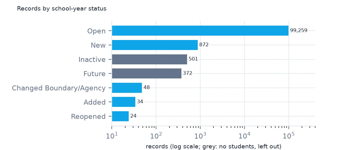
Not every row is a school in operation. 99,259 are open and 872 new this year, but 501 are inactive and 372 are future schools that have not opened, and none of those 873 has students. The pages in this cluster keep the open, new, reopened, added and changed schools: 100,237 in all.
3. Codes that are not numbers
for c in ["TOTAL", "FTE", "TOTFRL", "DIRECTCERT"]:
    print(c, sch[c].where(sch[c] < 0).value_counts().sort_index().to_dict())
TOTAL {-9.0: 54, -2.0: 1662, -1.0: 149}
FTE {-9.0: 100, -2.0: 873, -1.0: 3963}
TOTFRL {-9.0: 4953, -2.0: 7212, -1.0: 8532}
DIRECTCERT {-9.0: 1662, -2.0: 7212, -1.0: 42192}
Count columns hold negative codes where there is no number: -1 for missing, -2 for not applicable and -9 for a value that failed NCES's quality checks. 1,662 schools have -2 in TOTAL, and direct certification, which many states do not report, has 42,192 entries of -1. Summing a column without removing them understates every total; the codes page measures by how much.
4. The points
print(g.total_bounds.round(2))
fifty = g[~g.LSTATE.isin(["PR", "GU", "VI", "AS", "MP", "BI"])]
print(f"outside the 50 states and DC: {len(g) - len(fifty)}; by territory: {g[~g.index.isin(fifty.index)].LSTATE.value_counts().to_dict()}")
[-174.2 -14.35 145.78 71.3 ]
outside the 50 states and DC: 991; by territory: {'PR': 862, 'GU': 45, 'MP': 35, 'AS': 28, 'VI': 21}
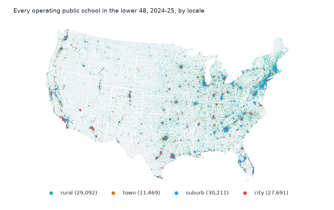
The points run from Atka in the Aleutians at 174.2° W to Saipan at 145.8° E, and from American Samoa at 14.35° S to Alaska's north coast at 71.3° N. 991 schools lie outside the 50 states and DC, 862 of them in Puerto Rico, so a map of the lower 48 should filter by state rather than trust a bounding box drawn around the data.
Counts by state and level
The data used on this page
NCES's Public School Characteristics layer from the Education Demographic and Geographic Estimates (EDGE) program: the 2024-25 Common Core of Data on EDGE's school points, every record of its ArcGIS service, downloaded on 28 October 2026 and saved on this site, because the "Current" layer is replaced each school year. Public domain. Counts are headcounts reported by state education agencies; teachers are full-time equivalents.
from pathlib import Path
import zipfile

import geopandas as gpd
import numpy as np
import pandas as pd
import requests

Path("data").mkdir(exist_ok=True)
# NCES EDGE "Public School Characteristics" for 2024-25 (the Common Core of Data on EDGE's school points), EDGE's school
# neighborhood poverty estimates for 2021-22, and the Census Bureau's 2024 counties and states. Saved 28 October 2026:
# the "Current" layers are replaced every school year.
# Live: https://services1.arcgis.com/Ua5sjt3LWTPigjyD/arcgis/rest/services/School_Characteristics_Current/FeatureServer/1
ARCHIVE = "nces-schools-2026-10-28.zip"
if not Path(f"data/{ARCHIVE}").exists():
    Path(f"data/{ARCHIVE}").write_bytes(requests.get(f"https://data.spatialworkflow.io/{ARCHIVE}", timeout=600).content)
Z = zipfile.ZipFile(f"data/{ARCHIVE}")
sch = pd.read_csv(Z.open("school-characteristics-2024-25.csv"), dtype={"NCESSCH": str, "LEAID": str, "CNTY": str, "LZIP": str, "LSTREET2": str})
for f in ["cb_2024_us_county_20m.zip", "cb_2024_us_state_20m.zip"]:
    Path(f"data/{f}").write_bytes(Z.read(f))
print(f"NCES public schools 2024-25: {len(sch):,} records")
NCES public schools 2024-25: 101,110 records
Example 1: schools and students by state
op = sch[sch.SY_STATUS_TEXT.isin(["Open", "New", "Reopened", "Added", "Changed Boundary/Agency"])]
by = op.assign(students=op.TOTAL.where(op.TOTAL >= 0)).groupby("LSTATE").agg(schools=("NCESSCH", "size"), students=("students", "sum"))
print(by.sort_values("students", ascending=False).head(6).astype(int).to_string())
print(f"all: {len(op):,} operating schools, {by.students.sum():,.0f} students")
schools students
LSTATE
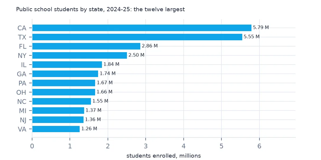
CA 10305 5790305
TX 9192 5545640
FL 4187 2856531
NY 4810 2503633
IL 4399 1843051
GA 2329 1744185
all: 100,237 operating schools, 49,343,524 students
The 100,237 operating schools enrol 49,343,524 students. California leads with 10,305 schools and 5,790,305 students, then Texas, Florida, New York, Illinois and Georgia. New York has more schools than Florida but fewer students: its schools are smaller.
Example 2: school level
t = op.assign(students=op.TOTAL.where(op.TOTAL >= 0)).groupby("SCHOOL_LEVEL").agg(schools=("NCESSCH", "size"), median_students=("students", "median"))
print(t.sort_values("schools", ascending=False).to_string())
schools median_students
SCHOOL_LEVEL
Elementary 52809 412.0
High 23829 369.0
Middle 16249 519.0
Other 4535 173.0
Prekindergarten 1626 100.0
Not Reported 411 NaN
Secondary 391 27.0
Not Applicable 281 3.0
Ungraded 98 0.0
Adult Education 8 0.0
Elementary schools are more than half of all schools, 52,809, with a median of 412 students. Middle schools are the largest, 519 at the median, and high schools smaller than expected at 369, because the level includes thousands of small alternative, career and technical, and special education high schools; regular high schools are much larger. "Other", "Not Applicable" and "Ungraded" are mostly special programmes with few or no students of their own; the 411 schools whose level is "Not Reported" have no enrolment figure at all.
Internal links
- The Common Core of Data explained — what each count means, and getting the data without code
- Codes of -1, -2 and -9 — the numbers that are not numbers
- Schools by county — the points on a map
- Locale codes explained — city, suburb, town and rural