
How to Find Where Charter Schools Enroll the Most Students
On this page
Problem statement
Charter schools are publicly funded schools run independently of the local district, and their share of students differs enormously between states. NCES's school file flags every charter, so the national picture is one group-by away. Two things complicate it: the flag has a third value, N, that is neither yes nor no, and a growing share of charter students attend online schools whose address says nothing about where their students live. This page measures the charter share of students by state, sorts out N, and looks at where charter students are by locale and city.
Quick answer
Keep the schools flagged Yes or No and compute the charter share of students per state:
ch = sch[sch.CHARTER_TEXT.isin(["Yes", "No"])]
t = ch.groupby(["LSTATE", "CHARTER_TEXT"]).TOTAL.sum().unstack()
t["share"] = t.Yes / (t.Yes + t.No)
print(t.share.sort_values(ascending=False).head(8).map("{:.1%}".format).to_string())
print(f"nation: {t.Yes.sum() / (t.Yes.sum() + t.No.sum()):.1%} of students in charter schools")
LSTATE
DC 44.5%
AZ 21.0%
NV 15.4%
CO 15.2%
LA 14.5%
FL 14.2%
DE 13.4%
ID 13.1%
nation: 8.2% of students in charter schools
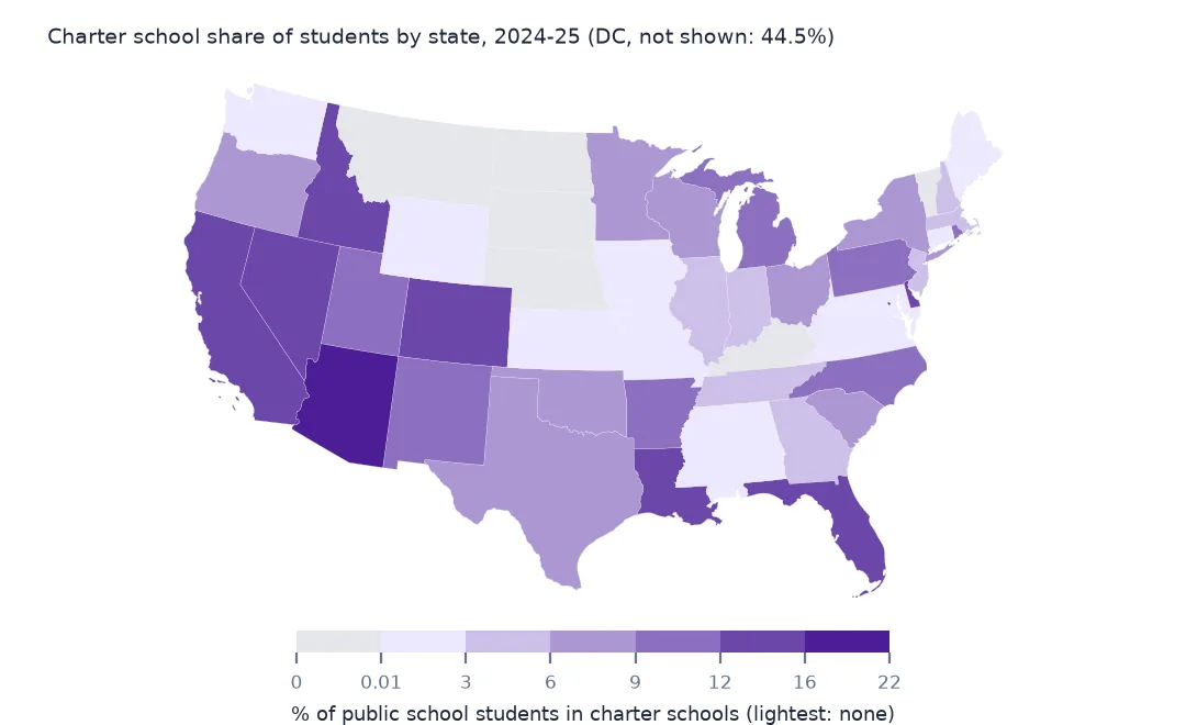
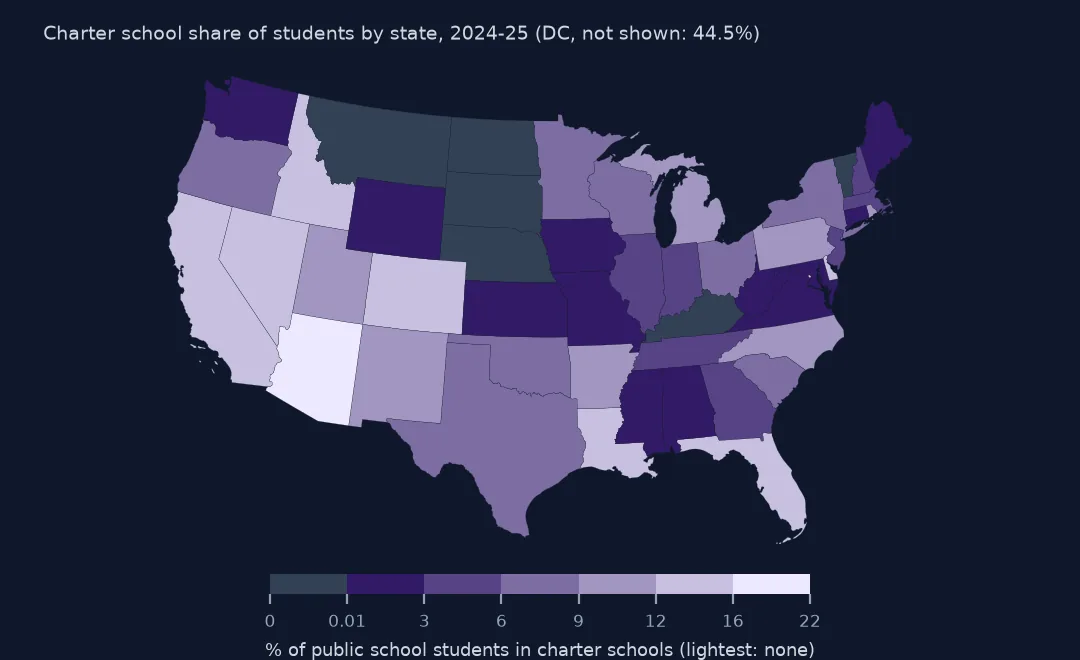
Nationally, 8.2% of public school students attend a charter school. The District of Columbia is in a class of its own at 44.5%, then Arizona at 21.0%, Nevada 15.4%, Colorado 15.2%, Louisiana 14.5% and Florida 14.2%. The share is of students, the figure that says how many children a state's charter sector serves.
The flag and the students behind it
1. Yes, No and N
print(sch.groupby("CHARTER_TEXT").agg(schools=("NCESSCH", "size"), students=("TOTAL", "sum")).astype(int).to_string())
n_share = sch.groupby("LSTATE").CHARTER_TEXT.apply(lambda s: (s == "N").mean())
print("N for every school:", sorted(n_share[n_share > 0.99].index))
print(sch[(sch.CHARTER_TEXT == "N") & ~sch.LSTATE.isin(n_share[n_share > 0.99].index)].LEA_NAME.value_counts().head(3).to_dict())
schools students
CHARTER_TEXT
N 3692 863548
No 88477 44522295
Yes 8068 3957681
N for every school: ['MP', 'MT', 'ND', 'NE', 'SD', 'VI', 'VT']
{'Big Stone City School District 25-1': 1, 'Rivendell Interstate School District': 1, "Naa Tsis'aan Community School": 1}
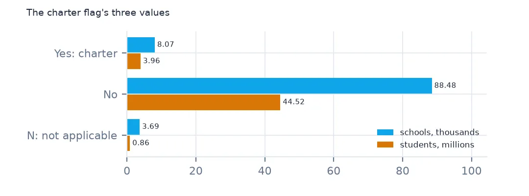
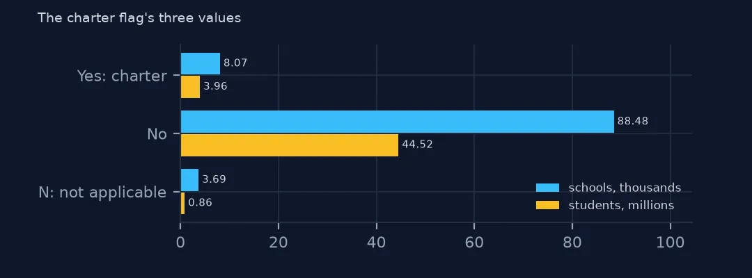
8,068 schools with 3,957,681 students are charters and 88,477 with 44,522,295 are not. The 3,692 schools marked N, not applicable, hold 863,548 students, and they are whole states: every school in Montana, North Dakota, South Dakota, Nebraska and Vermont, which reported no charter schools for 2024-25, plus the Northern Mariana Islands and the Virgin Islands. The few N schools elsewhere are odd cases such as an interstate district and a Bureau of Indian Education school. Counting N as missing would drop five states from the denominator; counting them as non-charter gives the national 8.2%.
2. Charters by locale
x = sch[sch.CHARTER_TEXT.isin(["Yes", "No"])].assign(locale=sch.ULOCALE.str[3:].str.split(":").str[0])
print(pd.crosstab(x.locale, x.CHARTER_TEXT, values=x.TOTAL, aggfunc="sum", normalize="columns").round(3).to_string())
CHARTER_TEXT No Yes
locale
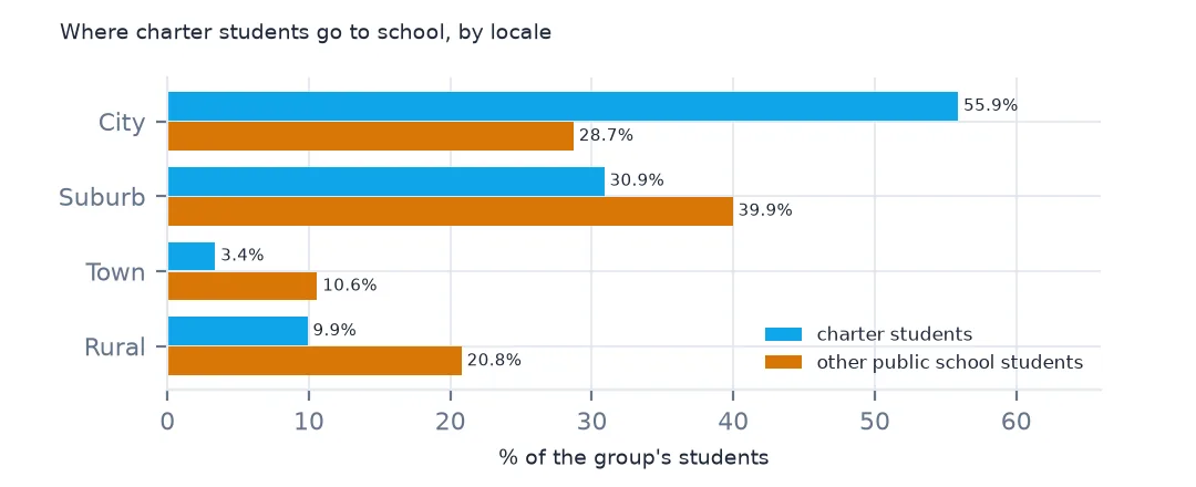
City 0.287 0.559
Rural 0.208 0.099
Suburb 0.399 0.309
Town 0.106 0.034
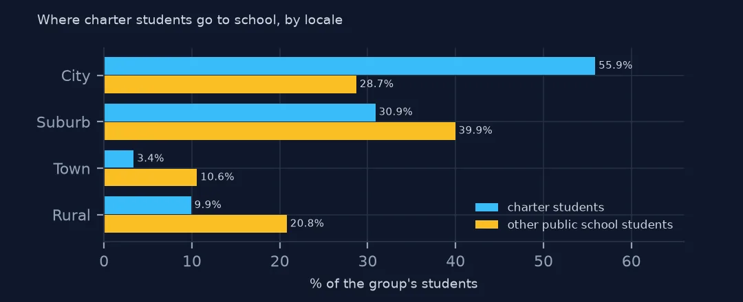
Charter students are concentrated in cities: 55.9% of them attend a school in a city locale, against 28.7% of other public school students. Only 9.9% are in rural schools, against 20.8%, and 3.4% in towns, against 10.6%. A state's charter share is mostly a measure of its cities.
3. Virtual charters
v = sch[sch.CHARTER_TEXT == "Yes"]
print(v.groupby("VIRTUAL").TOTAL.agg(["size", "sum"]).astype(int).to_string())
print(f"share of charter students in full-virtual charters: {v.loc[v.VIRTUAL == 'Full Virtual', 'TOTAL'].sum() / v.TOTAL.sum():.1%}")
size sum
VIRTUAL
Full Virtual 288 355253
M 1133 516739
Not Virtual 5750 2623584
Supplemental Virtual 774 342341
Virtual with face to face options 123 119764
share of charter students in full-virtual charters: 9.0%
288 charters are full-time virtual, with 355,253 students, 9.0% of all charter students. Another 1,133 charters, with 516,739 students, have no virtual status reported (M), so the true online share is at least 9.0%. Online charters enrol students across a whole state from one address, which is why the virtual schools page treats them separately on maps.
The largest charter cities
The data used on this page
NCES's Public School Characteristics layer from the Education Demographic and Geographic Estimates (EDGE) program: the 2024-25 Common Core of Data on EDGE's school points, every record of its ArcGIS service, downloaded on 28 October 2026 and saved on this site, because the "Current" layer is replaced each school year. Public domain. Counts are headcounts reported by state education agencies; teachers are full-time equivalents.
from pathlib import Path
import zipfile

import geopandas as gpd
import numpy as np
import pandas as pd
import requests

Path("data").mkdir(exist_ok=True)
# NCES EDGE "Public School Characteristics" for 2024-25 (the Common Core of Data on EDGE's school points), EDGE's school
# neighborhood poverty estimates for 2021-22, and the Census Bureau's 2024 counties and states. Saved 28 October 2026:
# the "Current" layers are replaced every school year.
# Live: https://services1.arcgis.com/Ua5sjt3LWTPigjyD/arcgis/rest/services/School_Characteristics_Current/FeatureServer/1
ARCHIVE = "nces-schools-2026-10-28.zip"
if not Path(f"data/{ARCHIVE}").exists():
    Path(f"data/{ARCHIVE}").write_bytes(requests.get(f"https://data.spatialworkflow.io/{ARCHIVE}", timeout=600).content)
Z = zipfile.ZipFile(f"data/{ARCHIVE}")
sch = pd.read_csv(Z.open("school-characteristics-2024-25.csv"), dtype={"NCESSCH": str, "LEAID": str, "CNTY": str, "LZIP": str, "LSTREET2": str})
for f in ["cb_2024_us_county_20m.zip", "cb_2024_us_state_20m.zip"]:
    Path(f"data/{f}").write_bytes(Z.read(f))
print(f"NCES public schools 2024-25: {len(sch):,} records")
sch["LSTATE"] = sch.LSTATE.str.strip()                                    # stored padded to three characters
NUM = ["TOTAL", "FTE", "STUTERATIO", "TOTFRL", "FRELCH", "REDLCH", "DIRECTCERT", "AM", "AS_", "BL", "HP", "HI", "TR", "WH"]
sch[NUM] = sch[NUM].where(sch[NUM] >= 0)                                  # -1 missing, -2 not applicable, -9 below quality standards
sch = sch[sch.SY_STATUS_TEXT.isin(["Open", "New", "Reopened", "Added", "Changed Boundary/Agency"])]
print(f"operating schools: {len(sch):,}; students: {sch.TOTAL.sum():,.0f}")
NCES public schools 2024-25: 101,110 records
operating schools: 100,237; students: 49,343,524
Example 1: the largest charter districts' cities
big = sch[sch.CHARTER_TEXT == "Yes"].groupby(["LCITY", "LSTATE"]).TOTAL.sum().sort_values(ascending=False)
print(big.head(8).astype(int).to_string())
LCITY LSTATE
HOUSTON TX 96489
Los Angeles CA 72137
SAN ANTONIO TX 68654
Philadelphia PA 65775
Chicago IL 53505
PHOENIX AZ 51101
BRONX NY 50751
BROOKLYN NY 48162
By the city in the school's address, Houston has the most charter students, 96,489, then Los Angeles, San Antonio, Philadelphia, Chicago and Phoenix. The address city is a rough key: New York City appears as its boroughs, the Bronx with 50,751 and Brooklyn with 48,162, and a city's charters can also sit under the names of its neighbourhoods. Join to place or county codes for a real city total; this list shows where charter schools are densest, not exact city counts.
Internal links
- The Common Core of Data explained — what a state reports, and getting the data without code
- Virtual schools on maps — the online charters that sit at one address
- Locale codes explained — the city and suburb classes used here
- Student-teacher ratios — another comparison across states