
How to Find Bank Deserts: Distance From Every Neighbourhood to a Branch
On this page
Problem statement
A bank desert is a place where the nearest branch is too far to reach easily, and counting branches per county cannot find one: a county can have several branches and still leave its far corner an hour from any of them. Distance from where people live to the nearest branch can. The Census Bureau publishes the centre of population of every census tract, and the Summary of Deposits the location of every branch, so the distance for the whole country is one nearest-neighbour join. This page measures it for 334,735,155 people, finds the farthest places and the states with the most people far from a branch, and shows which tracts became deserts since 2015.
Quick answer
Join each tract's centre of population to the nearest full-service branch in an equal-area projection and add up the people beyond each distance:
tr = pd.read_csv(Z.open("CenPop2020_Mean_TR.txt"), encoding="utf-8-sig", dtype={"STATEFP": str, "COUNTYFP": str, "TRACTCE": str})
tracts = gpd.GeoDataFrame(tr, geometry=gpd.points_from_xy(tr.LONGITUDE, tr.LATITUDE), crs=4269).to_crs(5070)
full = sod[sod.BRSERTYP.isin([11, 12]) & sod.SIMS_LATITUDE.notna()]
br = gpd.GeoDataFrame(full[["UNINUMBR"]], geometry=gpd.points_from_xy(full.SIMS_LONGITUDE, full.SIMS_LATITUDE), crs=4326).to_crs(5070)
near = gpd.sjoin_nearest(tracts, br, how="left", distance_col="m")
near = near[~near.index.duplicated()]
near["miles"] = near.m / 1609.34
print(f"tracts: {len(near):,}; people: {near.POPULATION.sum():,}")
for mi in [2, 5, 10, 25]:
    print(f"people more than {mi} miles from a full-service branch: {near.loc[near.miles > mi, 'POPULATION'].sum():,} ({near.loc[near.miles > mi, 'POPULATION'].sum() / near.POPULATION.sum():.2%})")
tracts: 85,395; people: 334,735,155
people more than 2 miles from a full-service branch: 68,074,084 (20.34%)
people more than 5 miles from a full-service branch: 20,051,480 (5.99%)
people more than 10 miles from a full-service branch: 2,865,388 (0.86%)
people more than 25 miles from a full-service branch: 291,472 (0.09%)
The 85,395 tracts hold 334,735,155 people. 20.34% of them, 68,074,084, live more than 2 miles from a full-service branch, 5.99% more than 5 miles and 2,865,388, 0.86%, more than 10 miles. 291,472 people live more than 25 miles away. Which distance makes a desert depends on the place: 2 miles is a long way without a car in a city, 10 miles normal in farm country.
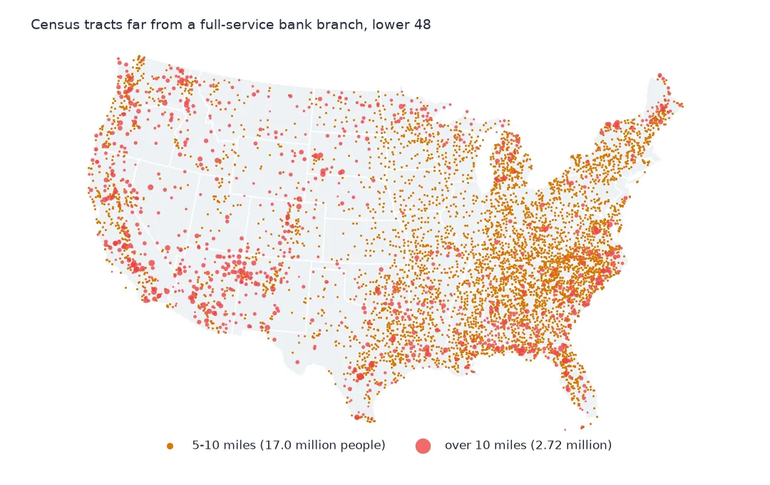
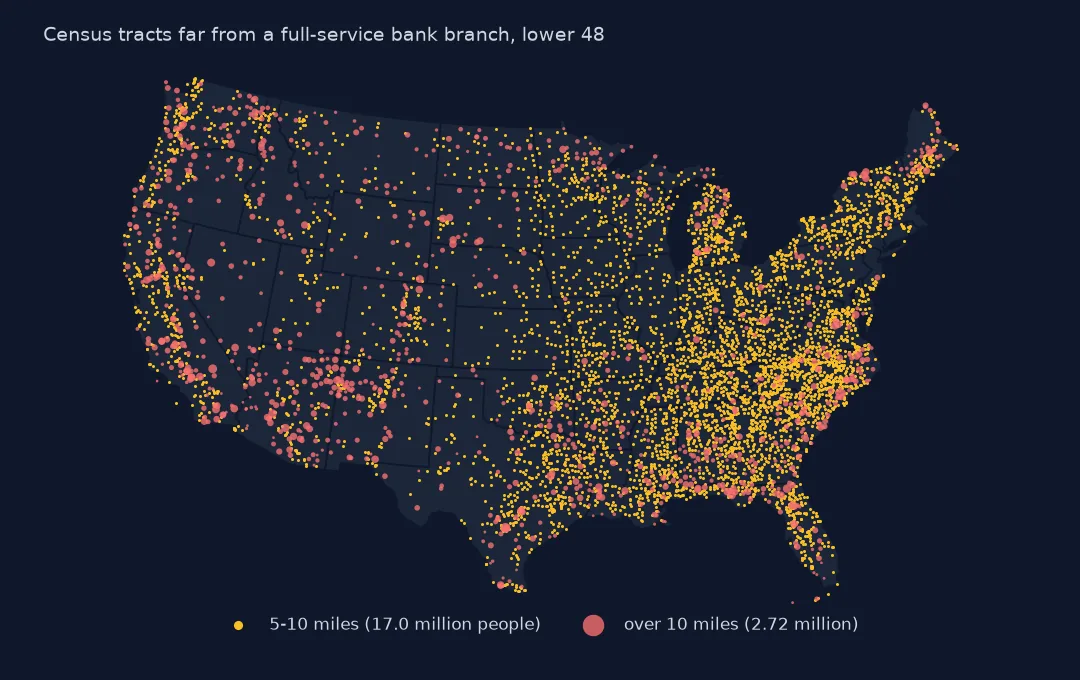
The farthest tracts, the states and the averages
1. The farthest
print(f"tracts with no residents: {(near.POPULATION == 0).sum()}")
print(near[near.POPULATION > 0].nlargest(5, "miles")[["STATEFP", "COUNTYFP", "TRACTCE", "POPULATION", "miles"]].round(1).to_string(index=False))
tracts with no residents: 614
STATEFP COUNTYFP TRACTCE POPULATION miles
02 016 000100 978 395.3
02 185 000300 2730 238.6
02 290 000300 1708 233.2
02 290 000400 1071 196.2
02 282 000100 662 166.9
614 tracts have no residents, and one of them, in the Northwestern Hawaiian Islands, is more than a thousand miles from a branch; they are dropped from the list. The farthest inhabited tracts are all in Alaska: the Aleutians West tract with 978 people is 395 miles from the nearest full-service branch, and tracts on the North Slope and in Yukon-Koyukuk 196 to 239 miles. Many Alaskan villages are reached only by air, and their banking is done by mail, credit union or not at all.
2. By state
st = near.groupby("STATEFP").apply(lambda d: d.loc[d.miles > 10, "POPULATION"].sum() / d.POPULATION.sum())
print(st.sort_values(ascending=False).head(6).map("{:.1%}".format).to_string())
STATEFP
02 15.1%
56 7.2%
35 7.0%
46 6.4%
38 6.0%
30 5.3%
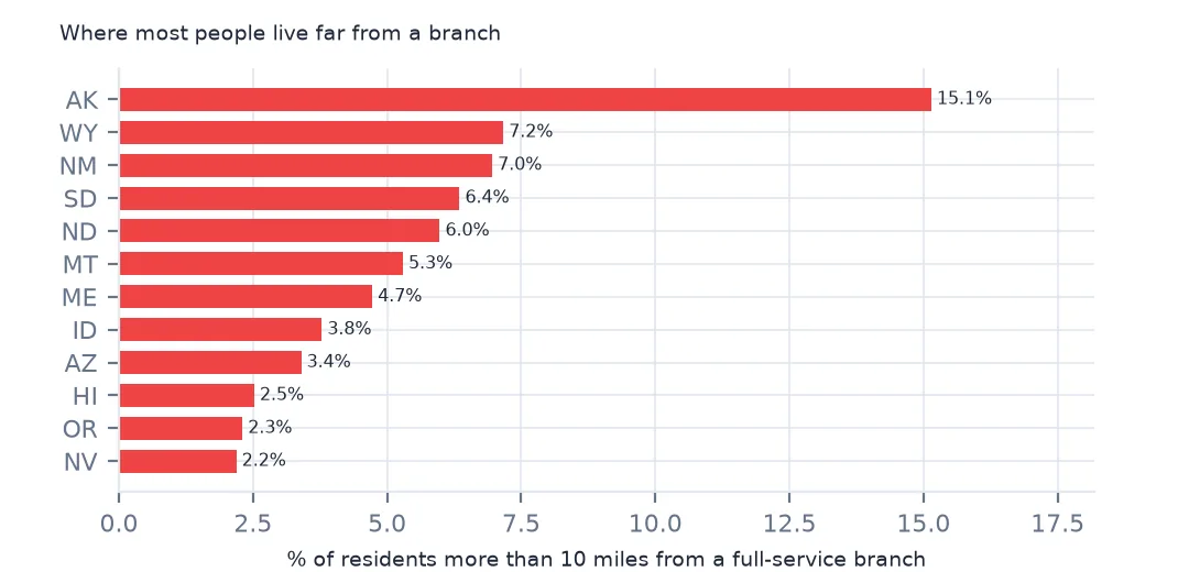
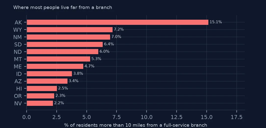
By state, 15.1% of Alaskans live more than 10 miles from a branch, then Wyoming at 7.2%, New Mexico at 7.0% and South Dakota, North Dakota and Montana at 5% to 6.4%. These are the most thinly settled states, where a branch serves a wide area.
3. What the tract centre hides
print(f"people-weighted mean distance: {np.average(near.miles, weights=near.POPULATION):.2f} miles; tracts with a branch within a mile: {(near.miles <= 1).mean():.1%}")
print(f"largest tract population more than 10 miles out: {near.loc[near.miles > 10, 'POPULATION'].max():,}")
people-weighted mean distance: 1.56 miles; tracts with a branch within a mile: 55.9%
largest tract population more than 10 miles out: 10,885
Weighted by people, the average distance to the nearest branch is 1.56 miles, and 55.9% of tracts have one within a mile. The largest tract more than 10 miles out has 10,885 people. A tract's centre of population is a single point; people at the edge of a large rural tract live further away than the centre suggests, so these figures understate the distances in the largest tracts.
Deserts that opened since 2015
The data used on this page
The FDIC's Summary of Deposits for 2015 and 2025, every office of every FDIC-insured institution with its deposits as of 30 June, from the BankFind Suite API, downloaded on 28 October 2026 and saved on this site, because banks amend past reports and the API serves the revised figures. Public domain. Deposits are reported in thousands of dollars. County populations are the Census Bureau's Vintage 2024 estimates, tract centres of population its 2020 census file, and boundaries its 2024 cartographic files, all public domain.
from pathlib import Path
import zipfile

import geopandas as gpd
import numpy as np
import pandas as pd
import requests

Path("data").mkdir(exist_ok=True)
# FDIC Summary of Deposits for 2015 and 2025 (every branch, deposits as of 30 June) from the BankFind Suite API, with
# the Census Bureau's 2024 county population estimates, 2020 tract centres of population, counties and states.
# Saved 28 October 2026: the API serves revised years as banks amend their reports.
# Live: https://api.fdic.gov/banks/sod?filters=YEAR:2025&limit=10000&offset=0
ARCHIVE = "fdic-sod-2026-10-28.zip"
if not Path(f"data/{ARCHIVE}").exists():
    Path(f"data/{ARCHIVE}").write_bytes(requests.get(f"https://data.spatialworkflow.io/{ARCHIVE}", timeout=600).content)
Z = zipfile.ZipFile(f"data/{ARCHIVE}")
for f in ["cb_2024_us_county_20m.zip", "cb_2024_us_state_20m.zip"]:
    Path(f"data/{f}").write_bytes(Z.read(f))
def read_sod(year):
    d = pd.read_csv(Z.open(f"fdic-sod-{year}.csv"), dtype={"ZIPBR": str})
    d["STCNTYBR"] = d.STCNTYBR.astype(str).str.zfill(5)          # county FIPS, stored as a number
    d["deposits"] = d.DEPSUMBR * 1000                              # reported in thousands of dollars
    return d
sod = read_sod(2025)
print(f"FDIC Summary of Deposits 2025: {len(sod):,} offices, ${sod.deposits.sum() / 1e12:,.2f} trillion in deposits")
FDIC Summary of Deposits 2025: 76,097 offices, $18.10 trillion in deposits
Example 1: deserts that opened since 2015
old = read_sod(2015)
fo = old[old.BRSERTYP.isin([11, 12]) & old.SIMS_LATITUDE.notna()]
bo = gpd.GeoDataFrame(fo[["UNINUMBR"]], geometry=gpd.points_from_xy(fo.SIMS_LONGITUDE, fo.SIMS_LATITUDE), crs=4326).to_crs(5070)
n15 = gpd.sjoin_nearest(tracts, bo, how="left", distance_col="m15")
n15 = n15[~n15.index.duplicated()]
both = near.assign(miles15=n15.m15 / 1609.34)
newly = both[(both.miles > 10) & (both.miles15 <= 10)]
print(f"tracts more than 10 miles from a branch in 2025 but not in 2015: {len(newly)}, {newly.POPULATION.sum():,} people")
print(f"the reverse (a branch now within 10 miles): {((both.miles <= 10) & (both.miles15 > 10)).sum()} tracts")
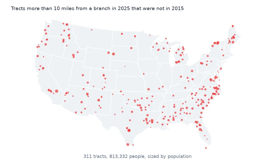
tracts more than 10 miles from a branch in 2025 but not in 2015: 311, 813,332 people
the reverse (a branch now within 10 miles): 59 tracts
311 tracts with 813,332 people were within 10 miles of a full-service branch in 2015 and are not in 2025, while 59 tracts moved the other way as new branches opened. Closures over the decade pushed far more people beyond reach than openings brought back, although the 2020 tract centres are used for both years, so the change is in the branches only.
Internal links
- Branch closures since 2015 — the closures behind the new deserts
- Branches per resident — the county view
- Distance to the nearest facility — the join used here
- Branch coordinates — how exact the branch points are