
How to Find Superfund Sites at Military Bases and Other Federal Facilities
On this page
Problem statement
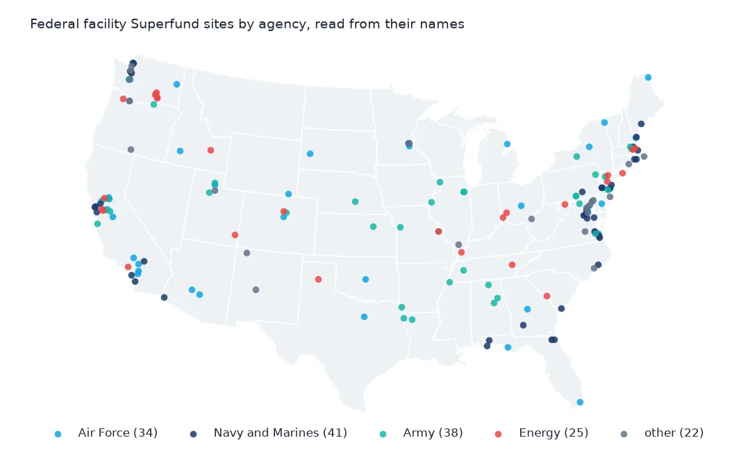
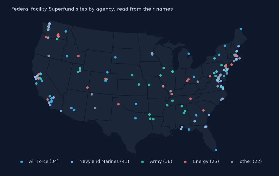
Some of the largest and slowest Superfund sites belong to the federal government itself: Air Force bases, naval air stations, Army ammunition plants and the nuclear weapons complex of the Department of Energy. The National Priorities List does not flag them, but EPA's site boundaries layer does, in FEDERAL_FACILITY_DETER_CODE, so joining the two finds every federal site. This page counts them, sorts them by agency from their names, maps where they are, and compares their progress and size with other Superfund sites.
Quick answer
Take the EPA ids flagged as federal facilities in the boundaries and mark them in the list:
bnd = gpd.read_file("data/npl-site-boundaries.geojson")
fed_ids = set(bnd.loc[bnd.FEDERAL_FACILITY_DETER_CODE == "Y", "EPA_ID"])
npl["federal"] = npl.Site_EPA_ID.isin(fed_ids)
print(f"federal facility sites: {npl.federal.sum()} of {len(npl):,}")
print(pd.crosstab(npl.federal, npl.Status).to_string())
federal facility sites: 171 of 1,840
Status Deleted NPL Site NPL Site Proposed NPL Site
federal
False 449 1185 35
True 17 152 2
171 of the 1,840 sites are federal facilities: 152 on the list, 2 proposed and only 17 deleted. Federal sites are a tenth of the list and a much smaller share of the sites that have been finished and taken off it.
Agencies, states and progress
1. Which agencies
f = npl[npl.federal]
kind = f.Site_Name.str.extract(r"(Air Force|Army|Nav(?:y|al)|Marine Corps|Department of Energy|DOE|Laboratory|Arsenal|Depot|Fort|Shipyard|Ammunition)", expand=False).fillna("other")
print(kind.value_counts().to_string())
Site_Name
Air Force 37
Naval 33
other 24
Army 22
DOE 16
Fort 12
Laboratory 9
Marine Corps 8
Navy 4
Arsenal 3
Depot 3
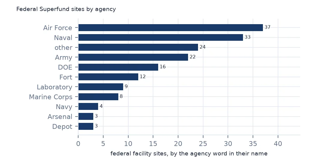
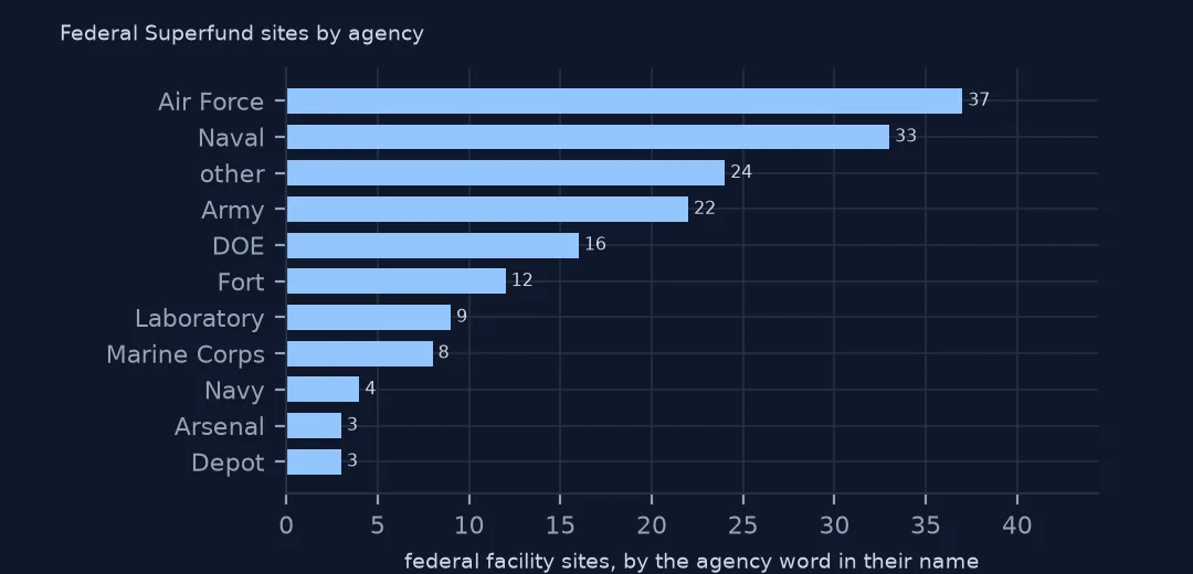
Read from the names, the Air Force has the most, 37, then naval sites, 33 plus 4 named Navy, and the Army 22, with 12 forts, 8 Marine Corps bases, 3 arsenals and 3 depots. 16 are named for the Department of Energy and 9 are national laboratories. 24 match none of the patterns: Camp Lejeune, the Aberdeen Proving Ground, a submarine base, a Coast Guard yard, and sites of the Department of Agriculture, the Interior Department and the Federal Aviation Administration. Many names carry the agency in brackets, such as (USARMY) or (USDOI), which a second pattern could use; EPA's site profiles name it for all.
2. Where
print(f.State.value_counts().head(6).to_string())State
California 24
Washington 18
Maryland 10
Virginia 9
Massachusetts 8
New Jersey 8
California has the most federal sites, 24, then Washington with 18, which includes the Hanford nuclear site and the Puget Sound naval installations, Maryland with 10 and Virginia with 9. The federal sites follow the military and nuclear map of the Cold War.
3. How they fare
l = npl[npl.Listing_Date.notna()].copy()
l["complete"] = l.Construction_Completion_Date.notna()
print(l.groupby("federal").agg(sites=("Site_Name", "size"), complete=("complete", "mean"), deleted=("Deletion_Date", lambda s: s.notna().mean()), median_score=("Site_Score", "median")).round(3).to_string())
sites complete deleted median_score
federal
False 1629 0.717 0.273 42.895
True 169 0.456 0.101 45.100
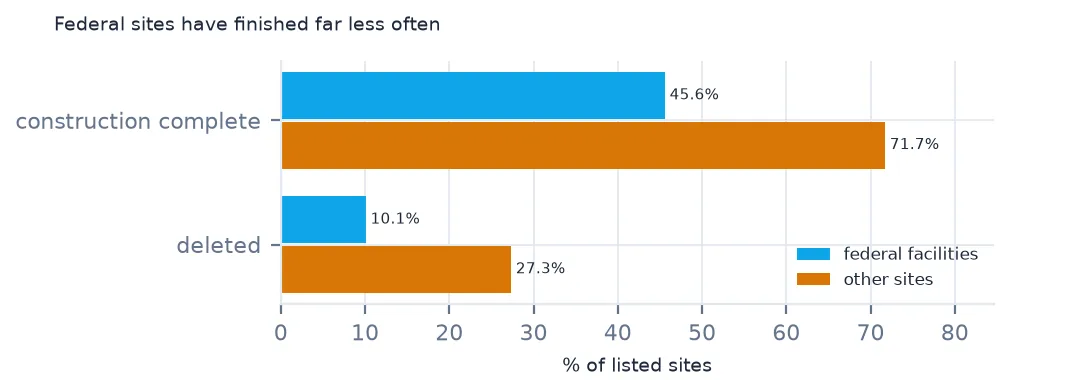
Federal sites move more slowly. 45.6% of listed federal sites have reached construction completion, against 71.7% of other sites, and 10.1% have been deleted, against 27.3%. Their median score is slightly higher, 45.100 against 42.895. Federal sites are larger, often with dozens of separate contaminated areas, and a site is not complete until all are done.
The largest federal sites
The data used on this page
The US Environmental Protection Agency's Superfund National Priorities List (NPL) Sites with Status Information and its national Superfund site boundaries, every record of both ArcGIS layers, downloaded on 28 October 2026 and saved on this site, because EPA edits both as sites are proposed, listed, completed and deleted. Public domain. The contact names, telephone numbers and e-mail addresses of EPA staff in the boundary layer were left out of the copy.
from pathlib import Path
import zipfile

import geopandas as gpd
import numpy as np
import pandas as pd
import requests

Path("data").mkdir(exist_ok=True)
# EPA's Superfund National Priorities List with status information and EPA's Superfund site boundaries, with the
# Census Bureau's 2020 tract centres of population, 2024 county estimates, counties and states. Saved 28 October 2026:
# EPA updates both layers as sites are proposed, listed, completed and deleted.
# Live: https://services.arcgis.com/cJ9YHowT8TU7DUyn/arcgis/rest/services/Superfund_National_Priorities_List_(NPL)_Sites_with_Status_Information/FeatureServer/0
ARCHIVE = "epa-superfund-npl-2026-10-28.zip"
if not Path(f"data/{ARCHIVE}").exists():
    Path(f"data/{ARCHIVE}").write_bytes(requests.get(f"https://data.spatialworkflow.io/{ARCHIVE}", timeout=600).content)
Z = zipfile.ZipFile(f"data/{ARCHIVE}")
for f in ["npl-sites-status.geojson", "npl-site-boundaries.geojson", "cb_2024_us_county_20m.zip", "cb_2024_us_state_20m.zip"]:
    if not Path(f"data/{f}").exists():
        Path(f"data/{f}").write_bytes(Z.read(f))
npl = gpd.read_file("data/npl-sites-status.geojson")
npl = gpd.GeoDataFrame(npl.drop(columns="geometry"), geometry=gpd.points_from_xy(npl.Longitude, npl.Latitude), crs=4326)
DATES = ["Proposed_Date", "Listing_Date", "Construction_Completion_Date", "NOID_Date", "Deletion_Date"]
npl[DATES] = npl[DATES].apply(pd.to_datetime, format="%m/%d/%Y")        # stored as MM/DD/YYYY text
print(f"Superfund National Priorities List: {len(npl):,} sites, {npl.Status.value_counts().to_dict()}")
Superfund National Priorities List: 1,840 sites, {'NPL Site': 1337, 'Deleted NPL Site': 466, 'Proposed NPL Site': 37}
Example 1: the federal sites with the largest boundaries
fb = bnd[bnd.FEDERAL_FACILITY_DETER_CODE == "Y"].to_crs(5070)
fb["km2"] = fb.area / 1e6
print(fb.groupby("SITE_NAME").km2.sum().sort_values(ascending=False).head(5).round(0).to_string())
SITE_NAME
FORT WAINWRIGHT 3722.0
IDAHO NATIONAL ENGINEERING LABORATORY (USDOE) 2290.0
EDWARDS AIR FORCE BASE 1241.0
SAVANNAH RIVER SITE (USDOE) 940.0
CAMP PENDLETON MARINE CORPS BASE 494.0
The largest federal boundaries are enormous: Fort Wainwright in Alaska covers 3,722 km², the Idaho National Engineering Laboratory 2,290 km² and Edwards Air Force Base 1,241 km², followed by the Savannah River Site and Camp Pendleton. Those boundaries are the whole installation, not the contaminated ground inside it, so their area says how much land is under the site's management, not how much is polluted.
Internal links
- How long cleanup takes — the durations compared here
- Site boundaries — where the federal flag comes from
- People near Superfund sites — the bases with residents inside
- Joining the list to the boundaries — the id match used here