
Fixing Superfund Joins Between the Site List and the Site Boundaries
On this page
Problem statement
EPA publishes Superfund sites in two layers that look as if they share a key: the National Priorities List with status information, one point per site, and the site boundaries, one or more polygons per site. Both carry the EPA site id. Joined naively, the result has more rows than sites, loses some sites, gains others that are not on the list, and places a quarter of the list's points outside their own boundary. This page measures each mismatch and builds a join that gives one row per site with its outline.
Quick answer
Compare the ids in the two layers:
bnd = gpd.read_file("data/npl-site-boundaries.geojson")
ids_b, ids_s = set(bnd.EPA_ID), set(npl.Site_EPA_ID)
print(f"status list: {len(ids_s):,} sites; boundaries: {len(ids_b):,} sites in {len(bnd):,} features")
print(f"in the list only: {len(ids_s - ids_b)}; in the boundaries only: {len(ids_b - ids_s)}")
status list: 1,840 sites; boundaries: 1,908 sites in 2,114 features
in the list only: 17; in the boundaries only: 85
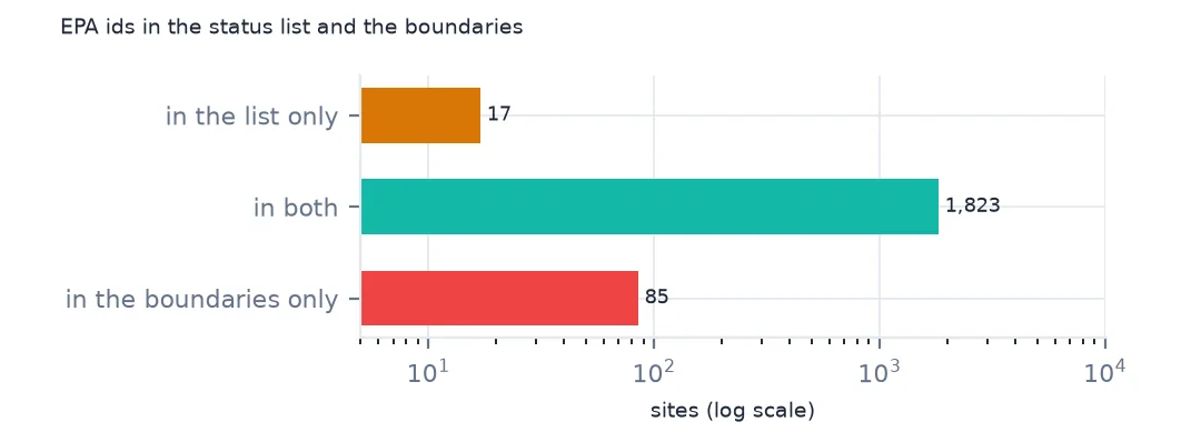
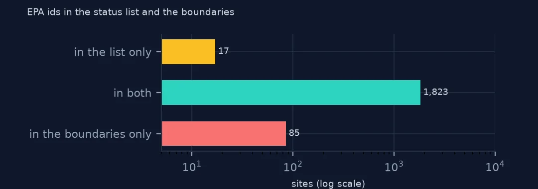
The status list has 1,840 sites and the boundaries 1,908 sites in 2,114 features. 17 listed sites have no boundary, and 85 boundary sites are not in the list. Neither layer is a subset of the other, so an inner join silently loses sites from both.
Extra boundaries, status codes and duplicates
1. Boundaries without a list entry
extra = bnd[~bnd.EPA_ID.isin(ids_s)]
print(extra.NPL_STATUS_CODE.value_counts().to_dict())
print(extra.SITE_NAME.head(4).tolist())
{'N': 70, 'R': 10, 'A': 4, 'S': 2}
['ALCOA AGGREGATION SITE', 'JANSSEN INC.', 'JOHNSON & TOWERS', 'NEWSTEAD SITE']
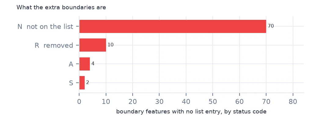
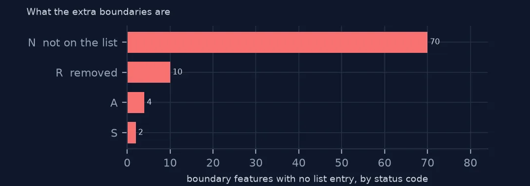
The 85 extra boundaries are not on the National Priorities List at all: 70 carry status code N, not on the list, 10 R, removed, 4 A and 2 S. They are sites EPA manages under Superfund without listing them, such as the Alcoa aggregation site and Johnson & Towers. Filter the boundaries to codes F, P and D before treating them as list sites.
2. Status that disagrees
one = bnd.drop_duplicates("EPA_ID").set_index("EPA_ID").NPL_STATUS_CODE
m = npl.set_index("Site_EPA_ID").Status.to_frame().join(one, how="inner")
print(pd.crosstab(m.Status, m.NPL_STATUS_CODE).to_string())
NPL_STATUS_CODE D F P
Status
Deleted NPL Site 465 0 0
NPL Site 0 1322 0
Proposed NPL Site 0 0 36
Where both layers have a site, their statuses agree completely: 465 deleted sites are D in the boundaries, 1,322 listed sites F and 36 proposed P. The status can be taken from either layer for matched sites.
3. Dissolve before joining
sites = bnd.dissolve("EPA_ID", as_index=False)[["EPA_ID", "geometry"]]
j = npl.merge(sites, left_on="Site_EPA_ID", right_on="EPA_ID", how="left", suffixes=("", "_b"))
print(f"rows after a join on undissolved features would be: {len(npl.merge(bnd[['EPA_ID']], left_on='Site_EPA_ID', right_on='EPA_ID'))}; after dissolving: {j.EPA_ID.notna().sum()}")
rows after a join on undissolved features would be: 2028; after dissolving: 1823
Joining the list to the undissolved features gives 2,028 rows, one for each feature of each site, so counts and sums double-count multi-feature sites. Dissolving the boundaries by EPA id first gives one outline per site, and 1,823 of the 1,840 list sites get one.
Points against their boundaries
The data used on this page
The US Environmental Protection Agency's Superfund National Priorities List (NPL) Sites with Status Information and its national Superfund site boundaries, every record of both ArcGIS layers, downloaded on 28 October 2026 and saved on this site, because EPA edits both as sites are proposed, listed, completed and deleted. Public domain. The contact names, telephone numbers and e-mail addresses of EPA staff in the boundary layer were left out of the copy.
from pathlib import Path
import zipfile

import geopandas as gpd
import numpy as np
import pandas as pd
import requests

Path("data").mkdir(exist_ok=True)
# EPA's Superfund National Priorities List with status information and EPA's Superfund site boundaries, with the
# Census Bureau's 2020 tract centres of population, 2024 county estimates, counties and states. Saved 28 October 2026:
# EPA updates both layers as sites are proposed, listed, completed and deleted.
# Live: https://services.arcgis.com/cJ9YHowT8TU7DUyn/arcgis/rest/services/Superfund_National_Priorities_List_(NPL)_Sites_with_Status_Information/FeatureServer/0
ARCHIVE = "epa-superfund-npl-2026-10-28.zip"
if not Path(f"data/{ARCHIVE}").exists():
    Path(f"data/{ARCHIVE}").write_bytes(requests.get(f"https://data.spatialworkflow.io/{ARCHIVE}", timeout=600).content)
Z = zipfile.ZipFile(f"data/{ARCHIVE}")
for f in ["npl-sites-status.geojson", "npl-site-boundaries.geojson", "cb_2024_us_county_20m.zip", "cb_2024_us_state_20m.zip"]:
    if not Path(f"data/{f}").exists():
        Path(f"data/{f}").write_bytes(Z.read(f))
npl = gpd.read_file("data/npl-sites-status.geojson")
npl = gpd.GeoDataFrame(npl.drop(columns="geometry"), geometry=gpd.points_from_xy(npl.Longitude, npl.Latitude), crs=4326)
DATES = ["Proposed_Date", "Listing_Date", "Construction_Completion_Date", "NOID_Date", "Deletion_Date"]
npl[DATES] = npl[DATES].apply(pd.to_datetime, format="%m/%d/%Y")        # stored as MM/DD/YYYY text
print(f"Superfund National Priorities List: {len(npl):,} sites, {npl.Status.value_counts().to_dict()}")
Superfund National Priorities List: 1,840 sites, {'NPL Site': 1337, 'Deleted NPL Site': 466, 'Proposed NPL Site': 37}
Example 1: does the list's point fall inside its boundary?
jj = j.dropna(subset=["EPA_ID"])
inside = gpd.GeoSeries(jj.geometry, crs=4326).within(gpd.GeoSeries(jj.geometry_b, crs=4326))
d = gpd.GeoSeries(jj.geometry, crs=4326).to_crs(5070).distance(gpd.GeoSeries(jj.geometry_b, crs=4326).to_crs(5070))
print(f"point inside its own boundary: {inside.mean():.1%}; median distance of the others: {d[~inside.values].median() / 1000:.2f} km; over 5 km: {(d > 5000).sum()}")
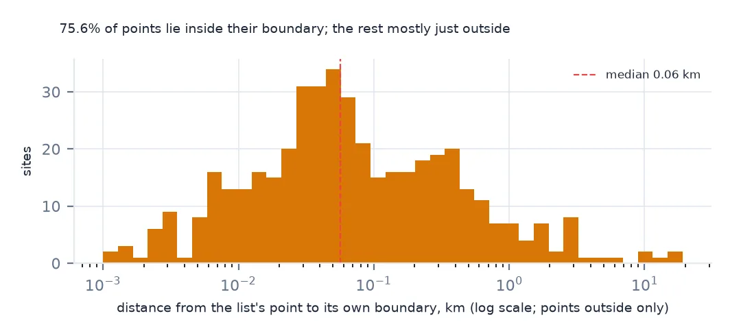
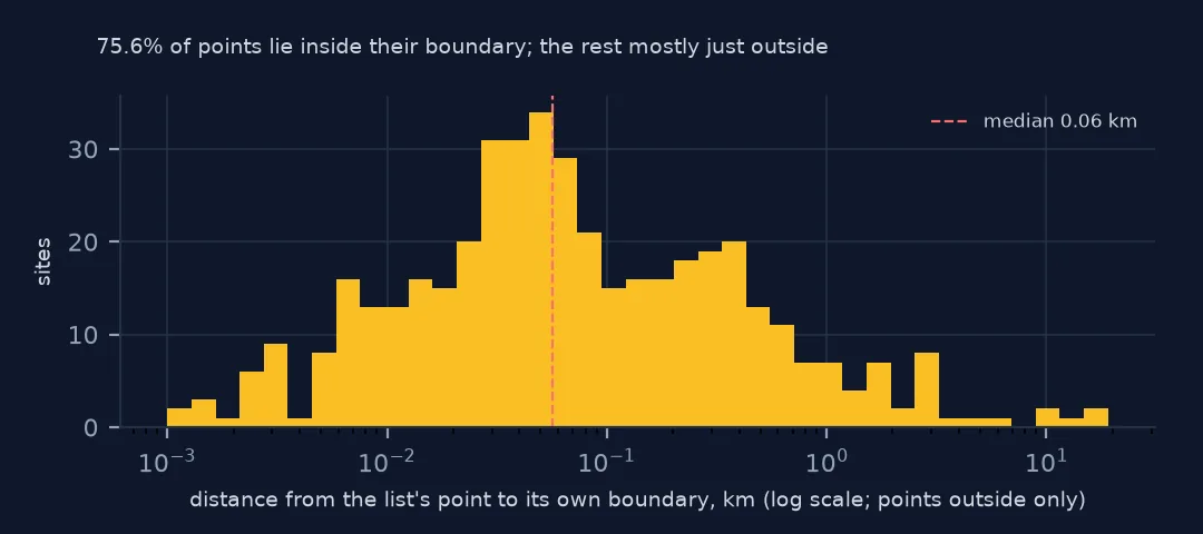
point inside its own boundary: 75.6%; median distance of the others: 0.06 km; over 5 km: 6
75.6% of the list's points lie inside their own site's boundary. The others are mostly just outside: the median distance is 0.06 km, a point placed at an address or entrance beside the contaminated area. Six are more than 5 km away and worth checking by hand. For any analysis of land or people near a site, use the boundary, not the point.
Internal links
- Reading the list — the status layer
- Site boundaries — the boundary layer
- Federal facilities — a flag that needs this join
- Spatial joins that duplicate rows — the general problem