
How Many Superfund Sites Are There? The National Priorities List Explained
On this page
Problem statement
How many Superfund sites are there? 1,337, if you mean sites on the National Priorities List today, but the list has held 1,840 sites in all since 1983, and a third of the early ones have been cleaned up and deleted. A site joins the list through a Hazard Ranking System score of 28.50 or more, moves through proposal, final listing, construction completion and deletion, and can take decades to do so. This page counts the sites at each stage, shows the score that admits them, follows how the list grew, and what became of each decade's sites.
Quick answer
Count the sites by status and by the milestones they have reached:
print(npl.Status.value_counts().to_string())
print(f"sites ever proposed: {len(npl):,}; ever listed: {npl.Listing_Date.notna().sum():,}; construction complete: {npl.Construction_Completion_Date.notna().sum():,}; deleted: {npl.Deletion_Date.notna().sum():,}")
Status
NPL Site 1337
Deleted NPL Site 466
Proposed NPL Site 37
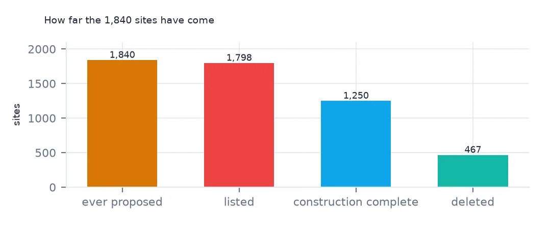
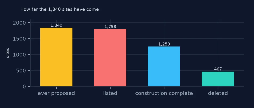
sites ever proposed: 1,840; ever listed: 1,798; construction complete: 1,250; deleted: 467
1,337 sites are on the list now, 466 deleted and 37 proposed. Of the 1,840 sites ever proposed, 1,798 have been listed, 1,250 have reached construction completion, the point when all physical cleanup works are built, and 467 have been deleted. Construction completion is not the end: groundwater treatment and monitoring can run for decades afterwards, and only deletion takes a site off the list.
Milestones, scores and growth
1. From proposal to deletion
steps = {"proposed": npl.Proposed_Date, "listed": npl.Listing_Date, "construction complete": npl.Construction_Completion_Date, "deleted": npl.Deletion_Date}
for k, v in steps.items():
    print(f"{k}: {v.notna().sum():,}, first {v.min():%Y-%m-%d}")
proposed: 1,840, first 1981-10-23
listed: 1,798, first 1983-09-08
construction complete: 1,250, first 1982-12-30
deleted: 467, first 1982-12-30
The first proposals date from October 1981 and the first final listings from September 1983. Construction completion and deletion both began in December 1982, with sites cleaned up while the list was still a proposal. Each milestone is published in the Federal Register, which is why the layer has a link to the notice for each one.
2. The score that puts a site on the list
print(npl.Site_Score.describe().round(2).loc[["count", "min", "50%", "max"]].to_string())
noscore = npl[npl.Site_Score.isna()]
print(f"no score: {len(noscore)}; listed in 1983 or earlier: {(noscore.Listing_Date.dt.year <= 1983).sum()}")
count 1777.00
min 28.51
50% 43.48
max 86.60
no score: 63; listed in 1983 or earlier: 36
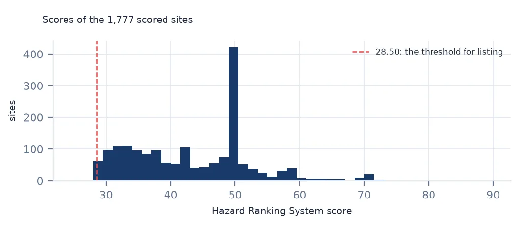
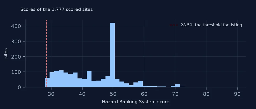
Every scored site has a Hazard Ranking System score of at least 28.51, the threshold of 28.50 being the score above which a site qualifies. The median is 43.48 and the highest 86.60. 63 sites have no score, and 36 of them were listed in 1983 or earlier: the law lets each state name one top-priority site without a score, though the layer does not say which sites those are.
3. How the list grew
y = npl.groupby(npl.Listing_Date.dt.year).size()
print(y.loc[[1983, 1984, 1986, 1990, 2000, 2010, 2020, 2024, 2025]].to_string())
print(f"listed since 2010: {y.loc[2010:].sum()}; 1983-1990: {y.loc[:1990].sum()}")
Listing_Date
1983.0 406
1984.0 132
1986.0 170
1990.0 171
2000.0 37
2010.0 17
2020.0 6
2024.0 7
2025.0 3
listed since 2010: 193; 1983-1990: 1204
The list was built mostly in its first years: 406 sites were listed in 1983, 132 in 1984 and 170 in 1986, and 1,204 of all listings came by 1990. Since 2010 only 193 have been added, a handful a year. A map of Superfund sites is therefore a map of contamination recognised in the 1980s.
What happened to each decade's sites
The data used on this page
The US Environmental Protection Agency's Superfund National Priorities List (NPL) Sites with Status Information and its national Superfund site boundaries, every record of both ArcGIS layers, downloaded on 28 October 2026 and saved on this site, because EPA edits both as sites are proposed, listed, completed and deleted. Public domain. The contact names, telephone numbers and e-mail addresses of EPA staff in the boundary layer were left out of the copy.
from pathlib import Path
import zipfile

import geopandas as gpd
import numpy as np
import pandas as pd
import requests

Path("data").mkdir(exist_ok=True)
# EPA's Superfund National Priorities List with status information and EPA's Superfund site boundaries, with the
# Census Bureau's 2020 tract centres of population, 2024 county estimates, counties and states. Saved 28 October 2026:
# EPA updates both layers as sites are proposed, listed, completed and deleted.
# Live: https://services.arcgis.com/cJ9YHowT8TU7DUyn/arcgis/rest/services/Superfund_National_Priorities_List_(NPL)_Sites_with_Status_Information/FeatureServer/0
ARCHIVE = "epa-superfund-npl-2026-10-28.zip"
if not Path(f"data/{ARCHIVE}").exists():
    Path(f"data/{ARCHIVE}").write_bytes(requests.get(f"https://data.spatialworkflow.io/{ARCHIVE}", timeout=600).content)
Z = zipfile.ZipFile(f"data/{ARCHIVE}")
for f in ["npl-sites-status.geojson", "npl-site-boundaries.geojson", "cb_2024_us_county_20m.zip", "cb_2024_us_state_20m.zip"]:
    if not Path(f"data/{f}").exists():
        Path(f"data/{f}").write_bytes(Z.read(f))
npl = gpd.read_file("data/npl-sites-status.geojson")
npl = gpd.GeoDataFrame(npl.drop(columns="geometry"), geometry=gpd.points_from_xy(npl.Longitude, npl.Latitude), crs=4326)
DATES = ["Proposed_Date", "Listing_Date", "Construction_Completion_Date", "NOID_Date", "Deletion_Date"]
npl[DATES] = npl[DATES].apply(pd.to_datetime, format="%m/%d/%Y")        # stored as MM/DD/YYYY text
print(f"Superfund National Priorities List: {len(npl):,} sites, {npl.Status.value_counts().to_dict()}")
Superfund National Priorities List: 1,840 sites, {'NPL Site': 1337, 'Deleted NPL Site': 466, 'Proposed NPL Site': 37}
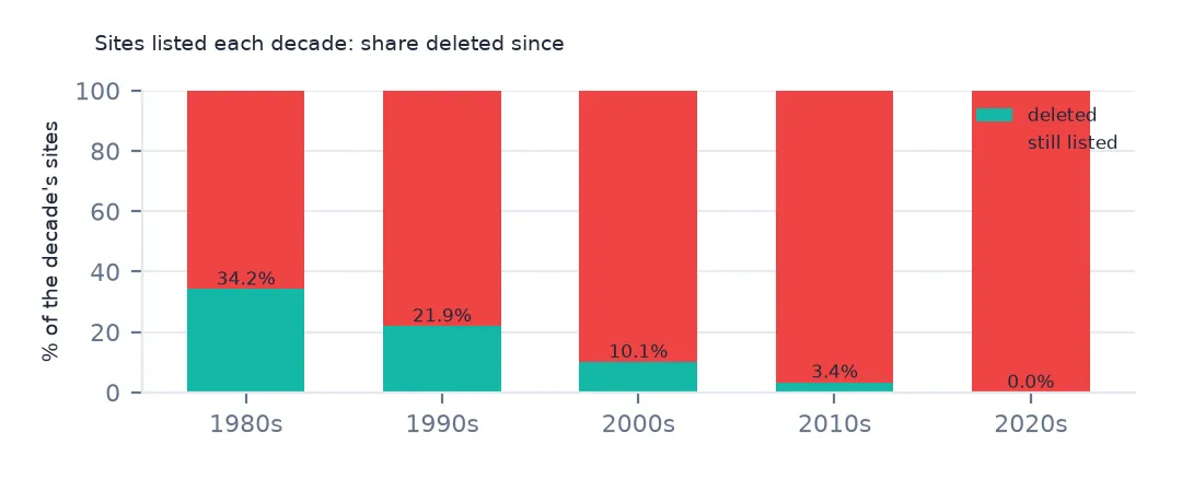
Example 1: what happened to the sites listed each decade
dec = npl[npl.Listing_Date.notna()].assign(decade=npl.Listing_Date.dt.year // 10 * 10)
print(pd.crosstab(dec.decade, dec.Status, normalize="index").round(3).to_string())
Status Deleted NPL Site NPL Site
decade
1980.0 0.342 0.658
1990.0 0.219 0.781
2000.0 0.101 0.899
2010.0 0.034 0.966
2020.0 0.000 1.000
Of the sites listed in the 1980s, 34.2% have since been deleted; of the 1990s', 21.9%; of the 2000s', 10.1%; and of the 2010s', 3.4%. None of the sites listed in the 2020s has been. The share deleted is largely a matter of time on the list, so a comparison of decades says more about how long cleanup takes than about whether newer sites are harder.
Getting the Superfund data without code
- Look first: EPA's Search for Superfund Sites Where You Live has a map and a search by place; each site has a profile page with its history, contaminants, cleanup decisions and contacts.
- The list itself: EPA's National Priorities List page has the current list, the sites proposed and deleted, and the Federal Register notices behind each step.
- Download: the layer these pages read is EPA's ArcGIS layer "Superfund National Priorities List (NPL) Sites with Status Information", which exports to a spreadsheet, GeoJSON or shapefile from its ArcGIS Online page; the site boundaries are a separate layer, "National NPL Superfund Site Boundaries". Both open in QGIS directly.
- What is included: every site proposed for the list since 1981, with its status: on the list, proposed or deleted. Sites cleaned up under other programmes or by states, which are far more numerous, are not in it.
- How current it is: EPA updates the layer as Federal Register notices are published. The copy these pages use was downloaded on 28 October 2026 and saved at data.spatialworkflow.io.
- Credit: US Environmental Protection Agency, Superfund National Priorities List, with the date you downloaded it. It is public domain.
Internal links
- Reading the list — the columns and their traps
- How long cleanup takes — listing to completion and deletion
- Hazard Ranking System scores — the score that admits a site
- Toxic releases from operating plants — the other side of industrial pollution