
How Many People Live Near a Superfund Site? Distances From Every Census Tract
On this page
Problem statement
How many Americans live near a Superfund site? EPA's own answer, about a fifth of the population within three miles, can be reproduced from public data: the Census Bureau publishes the centre of population of every census tract, and EPA the boundary of every Superfund site, so the distance from each tract to the nearest active site is one nearest-neighbour join. This page measures it for the whole country, finds the sites with the most people around them, compares states, and shows what a tract centre can and cannot say about exposure.
Quick answer
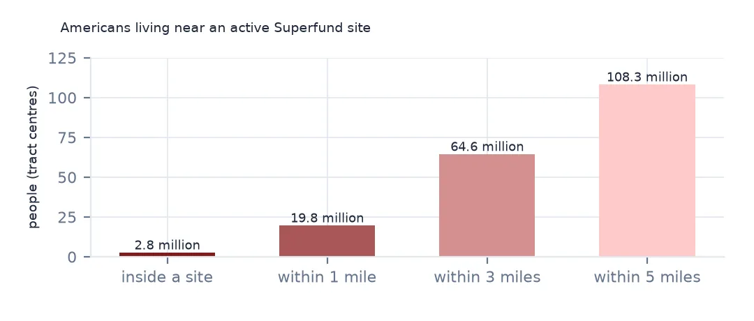
Join each tract's centre of population to the nearest boundary of a listed or proposed site, in an equal-area projection, and add up the people within each distance:
bnd = gpd.read_file("data/npl-site-boundaries.geojson")
active = bnd[bnd.NPL_STATUS_CODE.isin(["F", "P"])].to_crs(5070)
tr = pd.read_csv(Z.open("CenPop2020_Mean_TR.txt"), encoding="utf-8-sig", dtype={"STATEFP": str, "COUNTYFP": str, "TRACTCE": str})
tracts = gpd.GeoDataFrame(tr, geometry=gpd.points_from_xy(tr.LONGITUDE, tr.LATITUDE), crs=4269).to_crs(5070)
near = gpd.sjoin_nearest(tracts, active[["EPA_ID", "SITE_NAME", "geometry"]], how="left", distance_col="m")
near = near[~near.index.duplicated()]
near["miles"] = near.m / 1609.34
total = near.POPULATION.sum()
for mi in [0, 1, 3, 5]:
    k = near.miles <= mi
    print(f"people in tracts whose centre is within {mi} miles of an active site: {near.loc[k, 'POPULATION'].sum():,} ({near.loc[k, 'POPULATION'].sum() / total:.1%})")
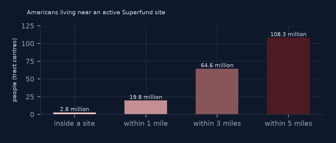
people in tracts whose centre is within 0 miles of an active site: 2,773,939 (0.8%)
people in tracts whose centre is within 1 miles of an active site: 19,799,540 (5.9%)
people in tracts whose centre is within 3 miles of an active site: 64,633,968 (19.3%)
people in tracts whose centre is within 5 miles of an active site: 108,349,860 (32.4%)
Measured from tract centres of population, 2,773,939 people live in tracts whose centre lies inside an active Superfund boundary, 19,799,540, 5.9% of the population, within a mile, 64,633,968, 19.3%, within three miles, and 108,349,860, nearly a third, within five. The three-mile figure is close to the one EPA publishes. Living near a site is not the same as being exposed to it: most contamination is in soil and groundwater on or under the site itself.
The sites, the states and the tract centres
1. Which sites have the most people around them
w = near[near.miles <= 1].groupby(["EPA_ID", "SITE_NAME"]).POPULATION.sum().sort_values(ascending=False)
print(w.head(6).to_string())
print(f"active sites with any tract centre within a mile: {len(w)} of {active.EPA_ID.nunique()}")
EPA_ID SITE_NAME
NYD980763841 HUDSON RIVER PCBS 2014600
NJD980528996 DIAMOND ALKALI CO. 548179
WA0002329803 LOWER DUWAMISH WATERWAY 398812
NYN000206282 NEWTOWN CREEK 309965
MON000705443 SOUTHWEST JEFFERSON COUNTY MINING 261853
CAD980677355 SAN GABRIEL VALLEY (AREA 1) 252248
active sites with any tract centre within a mile: 898 of 1358
Counting tract populations within a mile of each site, the Hudson River PCBs site has 2,014,600 people around it, because the site is a long stretch of the river running past dozens of towns down to New York City. Diamond Alkali in Newark, the Lower Passaic River, has 548,179, then Seattle's Lower Duwamish Waterway and Newtown Creek between Brooklyn and Queens. 898 of the 1,358 active sites have at least one tract centre within a mile; the rest are rural, industrial or military land.
2. By state
st = near.groupby("STATEFP").apply(lambda d: d.loc[d.miles <= 3, "POPULATION"].sum() / d.POPULATION.sum())
names = gpd.read_file("data/cb_2024_us_state_20m.zip").set_index("STATEFP").STUSPS
print(st.rename(index=names).sort_values(ascending=False).head(6).map("{:.1%}".format).to_string())
STATEFP
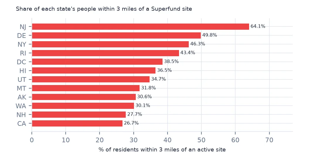
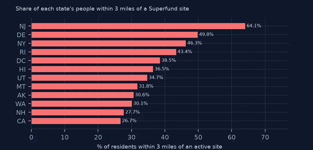
NJ 64.1%
DE 49.8%
NY 46.3%
RI 43.4%
DC 38.5%
HI 36.5%
By state, 64.1% of New Jersey residents live within three miles of an active site, the highest share in the country, then Delaware at 49.8%, New York 46.3% and Rhode Island 43.4%. DC and Hawaii follow, both with large military sites near their populations.
3. What a tract centre misses
inside = near[near.miles == 0]
print(f"tracts whose centre of population lies inside a site boundary: {len(inside)}, {inside.POPULATION.sum():,} people")
print(inside.nlargest(3, "POPULATION")[["STATEFP", "COUNTYFP", "TRACTCE", "POPULATION", "SITE_NAME"]].to_string(index=False))
tracts whose centre of population lies inside a site boundary: 720, 2,773,939 people
STATEFP COUNTYFP TRACTCE POPULATION SITE_NAME
06 073 018700 37892 CAMP PENDLETON MARINE CORPS BASE
51 710 000902 14006 NORFOLK NAVAL BASE (SEWELLS POINT NAVAL COMPLEX)
37 133 000600 13330 CAMP LEJEUNE MILITARY RES. (USNAVY)
720 tract centres lie inside a site boundary, with 2,773,939 people. The largest are military bases: a tract of 37,892 people inside Camp Pendleton, and others in the Norfolk naval complex and Camp Lejeune, where the base is the neighbourhood. A tract centre is one point for several thousand people; for exposure studies use block-level population or the boundaries of the contamination itself, not the whole site.
One county's sites
The data used on this page
The US Environmental Protection Agency's Superfund National Priorities List (NPL) Sites with Status Information and its national Superfund site boundaries, every record of both ArcGIS layers, downloaded on 28 October 2026 and saved on this site, because EPA edits both as sites are proposed, listed, completed and deleted. Public domain. The contact names, telephone numbers and e-mail addresses of EPA staff in the boundary layer were left out of the copy. Tract centres of population are the Census Bureau's 2020 file, county populations its Vintage 2024 estimates and boundaries its 2024 cartographic files, all public domain.
from pathlib import Path
import zipfile

import geopandas as gpd
import numpy as np
import pandas as pd
import requests

Path("data").mkdir(exist_ok=True)
# EPA's Superfund National Priorities List with status information and EPA's Superfund site boundaries, with the
# Census Bureau's 2020 tract centres of population, 2024 county estimates, counties and states. Saved 28 October 2026:
# EPA updates both layers as sites are proposed, listed, completed and deleted.
# Live: https://services.arcgis.com/cJ9YHowT8TU7DUyn/arcgis/rest/services/Superfund_National_Priorities_List_(NPL)_Sites_with_Status_Information/FeatureServer/0
ARCHIVE = "epa-superfund-npl-2026-10-28.zip"
if not Path(f"data/{ARCHIVE}").exists():
    Path(f"data/{ARCHIVE}").write_bytes(requests.get(f"https://data.spatialworkflow.io/{ARCHIVE}", timeout=600).content)
Z = zipfile.ZipFile(f"data/{ARCHIVE}")
for f in ["npl-sites-status.geojson", "npl-site-boundaries.geojson", "cb_2024_us_county_20m.zip", "cb_2024_us_state_20m.zip"]:
    if not Path(f"data/{f}").exists():
        Path(f"data/{f}").write_bytes(Z.read(f))
npl = gpd.read_file("data/npl-sites-status.geojson")
npl = gpd.GeoDataFrame(npl.drop(columns="geometry"), geometry=gpd.points_from_xy(npl.Longitude, npl.Latitude), crs=4326)
DATES = ["Proposed_Date", "Listing_Date", "Construction_Completion_Date", "NOID_Date", "Deletion_Date"]
npl[DATES] = npl[DATES].apply(pd.to_datetime, format="%m/%d/%Y")        # stored as MM/DD/YYYY text
print(f"Superfund National Priorities List: {len(npl):,} sites, {npl.Status.value_counts().to_dict()}")
Superfund National Priorities List: 1,840 sites, {'NPL Site': 1337, 'Deleted NPL Site': 466, 'Proposed NPL Site': 37}
Example 1: one city's sites
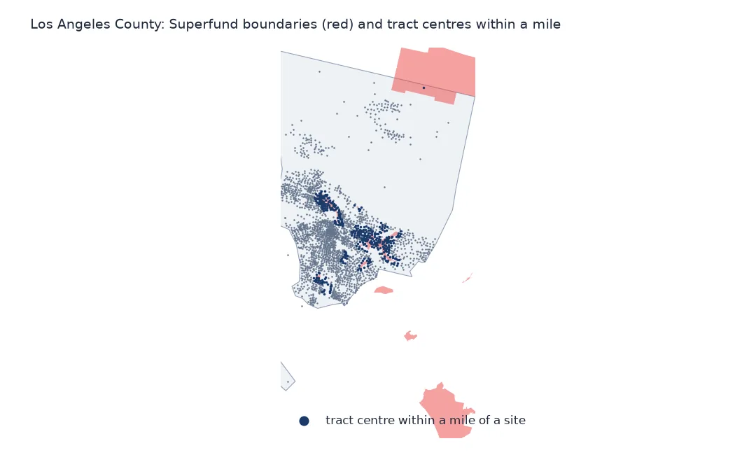
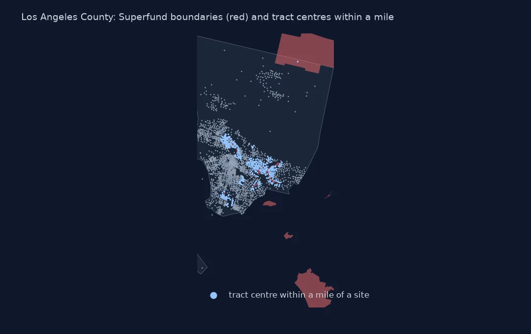
la = near[(near.STATEFP == "06") & (near.COUNTYFP == "037")]
print(f"Los Angeles County: {la.POPULATION.sum():,} people; within 1 mile of an active site: {la.loc[la.miles <= 1, 'POPULATION'].sum() / la.POPULATION.sum():.1%}")
print(la[la.miles <= 1].groupby("SITE_NAME").POPULATION.sum().sort_values(ascending=False).head(4).to_string())
Los Angeles County: 10,014,009 people; within 1 mile of an active site: 15.7%
SITE_NAME
SAN GABRIEL VALLEY (AREA 1) 252248
SAN GABRIEL VALLEY (AREA 3) 205877
SAN GABRIEL VALLEY (AREA 2) 197064
SAN FERNANDO VALLEY (AREA 1) 194239
In Los Angeles County, 15.7% of its 10,014,009 residents live in tracts within a mile of an active site. The San Gabriel Valley sites, areas 1 to 3, and the San Fernando Valley site account for most of them: they are groundwater plumes under whole suburbs, drawn as boundaries that cover hundreds of thousands of people.
Internal links
- Sites by county — the same sites counted by county
- Site boundaries — the outlines the distances are measured to
- Distance to the nearest hospital — the same tract-to-nearest method for hospitals
- Distance to the nearest facility — the join in general