
Fixing Superfund Site Areas Reported in Acres, Square Miles and Miles
On this page
Problem statement
EPA's Superfund boundary layer carries each site's area in GIS_AREA, with the unit beside it in GIS_AREA_UNITS, and the units are not one: acres for most features, square miles for some, and for 138 features just "Miles", which turns out to mean square miles too. Summed as stored, the column gives a total that is neither acres nor square miles. This page identifies each unit by comparing the stored value with the area of the outline, converts everything to acres, and measures how often the stored area and the drawn outline disagree.
Quick answer
Count the units as written and sum the column as stored:
bnd = gpd.read_file("data/npl-site-boundaries.geojson")
print(bnd.GIS_AREA_UNITS.value_counts(dropna=False).to_string())
print(f"sum of GIS_AREA as stored: {bnd.GIS_AREA.sum():,.0f} (in mixed units)")
GIS_AREA_UNITS
Acres 1556
Square Miles 382
Miles 138
NaN 34
acres 3
ACRES 1
sum of GIS_AREA as stored: 7,005,259 (in mixed units)
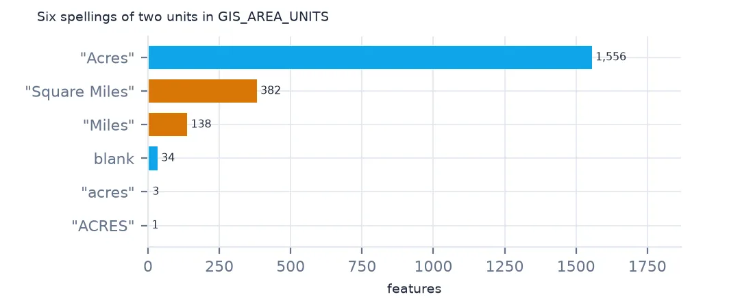
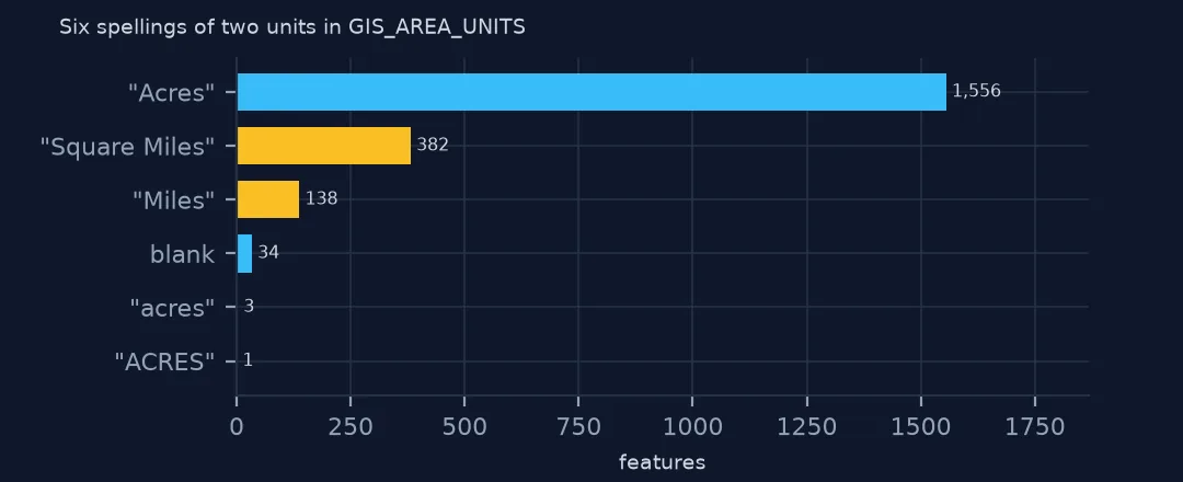
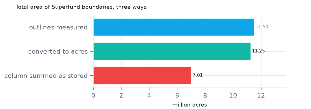
The units column has six values for three spellings and two units: 1,556 "Acres", 382 "Square Miles", 138 "Miles", 3 "acres", 1 "ACRES" and 34 blank. Summed regardless, GIS_AREA totals 7,005,259, a number in no unit at all.
Identify, convert and compare
1. Which unit each value is in
acres_geom = bnd.to_crs(5070).area / 4046.856
u = bnd.GIS_AREA_UNITS.str.lower()
for k in ["acres", "square miles", "miles"]:
    m = u == k
    print(f"{k}: GIS_AREA / outline acres, median {(bnd.GIS_AREA[m] / acres_geom[m]).median():.4f}; times 640: {(bnd.GIS_AREA[m] * 640 / acres_geom[m]).median():.3f}")
acres: GIS_AREA / outline acres, median 1.0000; times 640: 639.998
square miles: GIS_AREA / outline acres, median 0.0016; times 640: 1.001
miles: GIS_AREA / outline acres, median 0.0016; times 640: 1.000
Dividing each stored value by the area of its outline in acres settles it. For "acres" the median ratio is 1.0000. For "square miles" it is 0.0016, and multiplied by 640, the acres in a square mile, 1.001. "Miles" behaves exactly like square miles: times 640, its median ratio is 1.000. Lower-case everything, then convert both mile labels by 640.
2. Convert
TO_ACRES = {"acres": 1, "square miles": 640, "miles": 640}
bnd["acres"] = bnd.GIS_AREA * u.map(TO_ACRES)
print(f"total, converted: {bnd.acres.sum():,.0f} acres; from the outlines: {acres_geom.sum():,.0f}")
print(f"no GIS_AREA: {bnd.GIS_AREA.isna().sum()}")
total, converted: 11,245,915 acres; from the outlines: 11,495,050
no GIS_AREA: 54
Converted, the features cover 11,245,915 acres, close to the 11,495,050 acres of the outlines themselves. 54 features have no stored area at all and are left out of the converted total, which is part of the gap.
3. How far stored and drawn areas agree
r = bnd.acres / acres_geom
print(f"within 5% of the outline: {r.sub(1).abs().lt(0.05).mean():.1%}; off by more than half: {r.sub(1).abs().gt(0.5).sum()}")
print(bnd.assign(r=r.round(2)).loc[r.sub(1).abs().gt(0.5), ["SITE_NAME", "GIS_AREA", "GIS_AREA_UNITS", "r"]].head(4).to_string(index=False))
within 5% of the outline: 79.1%; off by more than half: 328
SITE_NAME GIS_AREA GIS_AREA_UNITS r
CLAREMONT POLYCHEMICAL 260.731289 Acres 3.45
ACTION ANODIZING, PLATING, & POLISHING CORP. 0.000000 Acres 0.00
GRAND STREET MERCURY 0.000000 Acres 0.00
LODI MUNICIPAL WELL 0.000000 Acres 0.00
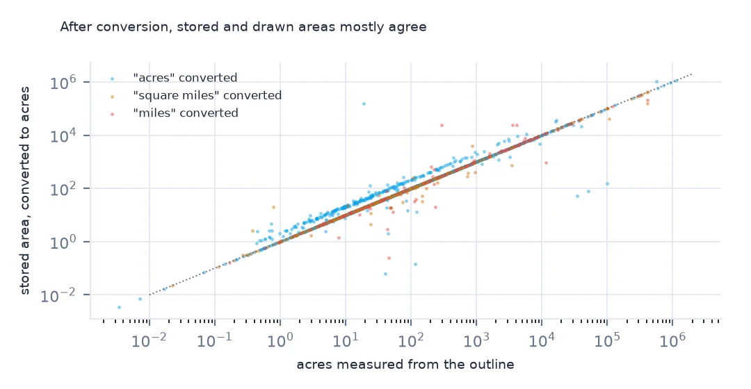
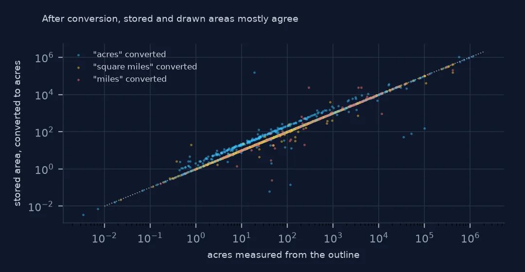
79.1% of features have a stored area within 5% of their outline, but 328 are off by more than half. Some stored values are 0, as for Action Anodizing and Grand Street Mercury, and some are several times the outline, like Claremont Polychemical at 3.45 times, probably because one of the two was revised without the other. When the two disagree, trust the outline's own area, computed in an equal-area projection.
The wrong total in a headline
The data used on this page
The US Environmental Protection Agency's Superfund National Priorities List (NPL) Sites with Status Information and its national Superfund site boundaries, every record of both ArcGIS layers, downloaded on 28 October 2026 and saved on this site, because EPA edits both as sites are proposed, listed, completed and deleted. Public domain. The contact names, telephone numbers and e-mail addresses of EPA staff in the boundary layer were left out of the copy.
from pathlib import Path
import zipfile

import geopandas as gpd
import numpy as np
import pandas as pd
import requests

Path("data").mkdir(exist_ok=True)
# EPA's Superfund National Priorities List with status information and EPA's Superfund site boundaries, with the
# Census Bureau's 2020 tract centres of population, 2024 county estimates, counties and states. Saved 28 October 2026:
# EPA updates both layers as sites are proposed, listed, completed and deleted.
# Live: https://services.arcgis.com/cJ9YHowT8TU7DUyn/arcgis/rest/services/Superfund_National_Priorities_List_(NPL)_Sites_with_Status_Information/FeatureServer/0
ARCHIVE = "epa-superfund-npl-2026-10-28.zip"
if not Path(f"data/{ARCHIVE}").exists():
    Path(f"data/{ARCHIVE}").write_bytes(requests.get(f"https://data.spatialworkflow.io/{ARCHIVE}", timeout=600).content)
Z = zipfile.ZipFile(f"data/{ARCHIVE}")
for f in ["npl-sites-status.geojson", "npl-site-boundaries.geojson", "cb_2024_us_county_20m.zip", "cb_2024_us_state_20m.zip"]:
    if not Path(f"data/{f}").exists():
        Path(f"data/{f}").write_bytes(Z.read(f))
npl = gpd.read_file("data/npl-sites-status.geojson")
npl = gpd.GeoDataFrame(npl.drop(columns="geometry"), geometry=gpd.points_from_xy(npl.Longitude, npl.Latitude), crs=4326)
DATES = ["Proposed_Date", "Listing_Date", "Construction_Completion_Date", "NOID_Date", "Deletion_Date"]
npl[DATES] = npl[DATES].apply(pd.to_datetime, format="%m/%d/%Y")        # stored as MM/DD/YYYY text
print(f"Superfund National Priorities List: {len(npl):,} sites, {npl.Status.value_counts().to_dict()}")
Superfund National Priorities List: 1,840 sites, {'NPL Site': 1337, 'Deleted NPL Site': 466, 'Proposed NPL Site': 37}
Example 1: the wrong total in a headline
raw_acres = bnd.loc[u == "acres", "GIS_AREA"].sum() + bnd.loc[u != "acres", "GIS_AREA"].sum()
print(f"adding the column as if all acres: {raw_acres:,.0f}; converted: {bnd.acres.sum():,.0f}; from outlines: {acres_geom.sum():,.0f}")
adding the column as if all acres: 7,005,259; converted: 11,245,915; from outlines: 11,495,050
Adding the column as if every value were acres gives 7,005,259 acres; converting the units gives 11,245,915, more than half as much again. A headline figure for "land in Superfund sites" built on the raw column would be off by four million acres, and in the wrong direction.
Internal links
- Site boundaries — areas computed from the outlines
- Choosing a projected CRS for area — computing areas correctly
- Joining the list to the boundaries — the other trap in this layer
- Reading the list — the status layer